Research
, Volume: 17( 2) DOI: 10.37532/0974-7451.2021.17(2).182TSRA days in Yangon International airport (Hourly analysis of 2009-2019)
- *Correspondence:
- Kyaw Than Oo, School of Atmospheric Science, Nanjing University of Information Science and Technology, Yangon, China, Tel: +95 9954 575 418; E-Mail: kyawthanoo34@outlook.com
Received: February 9, 2021; Accepted: February 24, 2021; Published: February 26, 2021
Citation:Kyaw Than Oo. TSRA days in Yangon International airport (Hourly analysis of 2009-2019), J Environ Sci. 2021; 17(2):182 © 2021 Trade Science Inc.
Abbreviations
Aeronautical Abbreviations
ICAO - International Civil Aviation Organization
METAR - Aviation Routine Weather Report
RWY - Runway
UTC - Universal Coordinated Time
Meteorological Abbreviations
CB - Cumulonimbus
Cloud amount: - BKN Broken (5-7 Octas), OVC Overcast (8 Octas)
Hs - Height of lower layer of cloud
WMO - World Meteorological Organization
Ta - 0C - Ambient temperature
Td – 0C - Dew point temperature
RH - Relative Humidity
QNH - Regional mean sea level atmospheric pressure
BR - Mist (Foggy conditions, when visibility is at least 1000 m but not more than 5000 m.)
RA - Rain
TS - Thunderstorm
FOG - Fog (Foggy conditions, when visibility is less than 1000 m.)
MIFG - Shallow fog, when the vertical extension of fog on a runway is less than 2 meters
DZ - drizzle
HZ - Haze
TSRA - Thunderstorm with Rain
SHRA - Shower Rain
MAPT - Mist Approach Point
OCH - Obstacle clearance height
TDZ - Touch down Zone
Airports
VYYY – Yangon International Airport
Abstract
“A Thunderstorm Day Is Defined As An Observational Day During Which Thunder Heard At The Station” (Kuleshov 2012). Thunderstorms have a significant impact on airport performance and cause delayed operations if the airport capacity is constrained. “TSRA days in Yangon International Airport” is a statistical analysis of the observations data obtained by the meteorological stations at YANGON international airports (VYYY) of Myanmar for Thunderstorm days occurrences. It covers an eleven-year period from January 2009 – December 2019. During 2009-2019, we have 119874 times of observation data from YANGON International Airport, thirty-minute (xx20, and xx50) Aviation Routine Weather Reports (METARs). Among these data, we got 20219 times of weather phenomena occurred including 1237 times of Thunderstorms occurrences. Visibility during Thunderstorm (TS) or thunderstorm rain (TSRA) the averaging visibility will be 3500 m with 6.67% frequencies during these 2009 to 2019. Maximum TSRA occurrences may be occurred between 15:00 to 16:30 afternoons in those TSRA days at Yangon international airport. For the aviation purpose, 00:00 UTC to 04:00 UTC is the better time for daytime operations in those TSRA days. This paper will first examine the impact of aviation climatology on these airports. And a statistical analysis of the observations data obtained by each meteorological stations. It is also intended for a wide range of users:
•international and domestic civil airlines which conduct flights to/from MYANMAR airports;
•private pilots;
•operational and administrative services of airports;
•aeronautical administration;
•air navigation services providers;
•The MYANMAR Civil Aviation Agency.
As the result of analysis, in July we can be faced many Thunderstorm days every year. Maximum TSRA occurrences may be occurred between 15:00 to 16:30 afternoons in those TSRA days at Yangon international airport. Thus, for the aviation purpose, 00:00 UTC to 04:00 UTC is the better time for daytime operations in those TSRA days and visibility will be 3500 m with 6.67% on average. Even non-El Niño/La Niña years, TSRA occurrences is up or increase year by year as the trend forecast results. Generally, in the future TSRA days may increase at VYYY. So, for the important operations we can be manage each operation requirement by time. That highly risk operations should be carrying out less TSRA months. Finally, the distributions provided in this paper could allow airports and airlines operators to forecast the average TSRA days at the infrastructure as a function of the current and forecast weather in order to apply mitigation strategies.
Keywords:
Yangon International Airport; TSRA; Aircraft Accident; Thunderstorm impact
Introduction
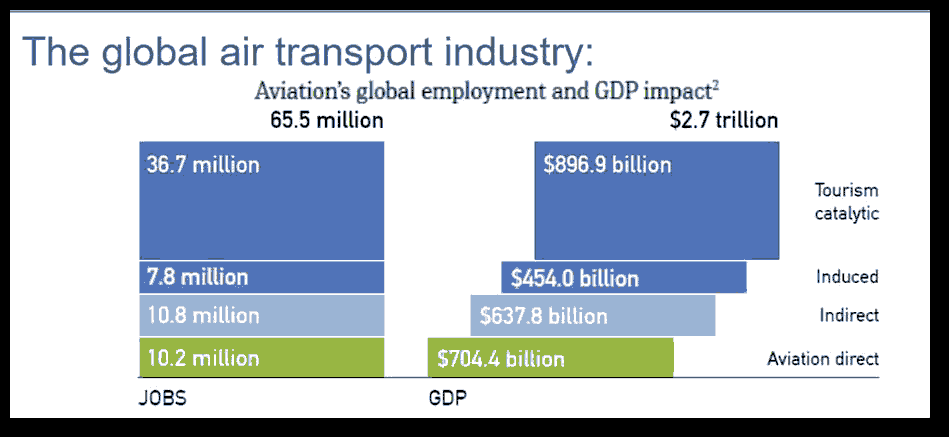
The aviation industry is a critical component of the economy of industrialized countries such as China; for landlocked countries and countries with limited road infrastructure such as Laos, and small island nation states such as Madagascar, the aviation industry is an indispensable vehicle for advancing economic growth and sustainable development. The aviation industry is also an important driver of the growth of other economic activities such as domestic trade, military operations and tourism [FIG.1.].
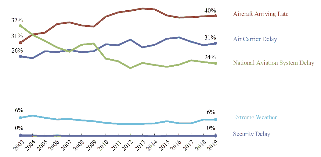
The Air Transport Action Group estimates that the aviation industry accounted for 704.4 billion dollars in direct gross benefits (2019) and 65.5 million jobs supported by aviation worldwide. Totally $2.7 trillion Aviation’s global economic impact (including direct, indirect, induced and tourism catalytic) and 3.6% of Global GDP supported by aviation (2019) [1]. Yearly analysis of flight delay causes [FIG.2]. Six percent of total delay volume due to weather [2]. Thus, weather also important for aviation industry benefits but unfortunately it is uncontrollable as mention before.
Weather is one of the most significant factors that affect how an aircraft operates as well as how safely it can do so. Meteorology is important for two basic reasons though. One is predicting and forecasting weather so that airplanes can plan for or avoid potentially dangerous conditions and two, it is important to better understand the minute details of what is actually going on in a storm system etc.
The relationship between aviation and meteorology spans more than a century. Climatology is anticipated to steer to drastic changes in the weather locally and probably to a lot of severe weather patterns. This is often possible to incorporate a lot of intense rain, and intense Thunderstorm Rain fall and other hailstorms and cyclones which cause the losses in the aviation industry and immobility or grounded flights.
herefore, the impact of weather on aviation can possibly increase with time, unless new solutions are tailored. Delays in aviation aren't utterly avertable. Because of the changing climatic conditions and weather simultaneously it drastically affects the performance of aircrafts at the airport and this cannot be avoided eventually. These delays are sometimes necessary to show that we put the safety of the people as our main priority. The accuracy of a forecast does TSRA impact on the number of departure delays. As of [FIG.1.], weather is the only uncontrollable factor among the mainly 5 kinds of aircraft delays. Therefore, the departure delays because of weather are for the most part inevitable. It's always necessary to be ready for departure delays, so as for aerodrome operations to run with efficiency, and thus planning is crucial (Lo 2013).
Aircraft must take off and land into the wind or with minimal tail wind [3]. This means current and forecast wind direction dictates the selection of runway/s in use at any time. Wind blowing across the runway is called a cross wind. Generally, aircraft can take off or land where there is only a low cross wind, usually up to a speed of about 15 knots (28 km/h) [4]. Visibility is also an important factor in all phases of flight, but especially when the aircraft is maneuvering on or close to the ground, i.e. during taxi-out, take-off and initial climb, approach and landing, and taxi-in. Aircraft departure and arrival is limited by the visibility (or RVR) to an extent that depends on the sophistication of ground equipment, the technical equipment fitted to the aircraft and the qualification of the flight crew (Skybrary.aero, Visibility). Many aerodromes and aircraft are fitted with equipment that makes possible a landing in very low visibility conditions provided the flight crew is suitably qualified; however, in very low visibility, it may prove impossible for the pilot to navigate the aircraft along the runway and taxiways to the aircraft stand.
Low cloud, fog and rain may impede visibility at or around an airport while thunderstorms and lightning can cause serious disruption to flight schedules. Thunderstorms, and the rapidly rising or falling air currents which usually accompany them, can make air travel uncomfortable for passengers and difficult for pilots in control of aircraft. Aircraft are unable to take-off or land during a storm and will often be re-routed around storm cells or diverted from their destinations. Thunderstorms and lightning strikes near airports may also stop ground operations until they pass.
Air services does not have the authority or ability to close an airport even bad weather condition on aerodrome [6]. Airport operators are the only authority able to close an airport and this decision would only be taken in extreme circumstances. Particularly wind speed and direction, is generally the major factor to determine which runways to use at an airport, in which direction aircraft will take off and land and which flight paths are used.
The Republic of the Union of Myanmar has 25 operating airports with commercial flights. The country is bordered by People's Republic of China to the northeast, Laos to the east, Thailand to the southeast, Bangladesh to the west, India to the northwest, the Bay of Bengal to the southwest, and the Andaman Sea to the south. The country is divided into 14 administrative subdivisions, which include 7 states (pyi-ne) and 7 divisions (tyne). Its capital is Naypyitaw (Nay Pyi Taw) and its largest city (and prior capital) is Yangon.
Myanmar has currently three international gateways. The country's newest airport stands in the capital Naypyidaw, but it's right in the middle of nowhere as far as tourists are concerned. Then there's MANDALAY International Airport, which is Myanmar's biggest, putting travelers closer to the country's most beloved tourist stops. The busiest airport in Myanmar (Burma) is Yangon (RGN) / Yangon International Airport with flights to 56 destinations in 14 countries and catering to about six million [7]. Yangon International Airport, located far to the south, is older but has better international connections than its northern rival.
Study area
Yangon International Airport (VYYY) is the primary and busiest international airport in Myanmar. The airport is located in Mingaladon, 15 kilometers (9.3 mi) north of central Yangon (165426.16N 0960759.66E). Elevation is 33.6 M (110 FT)/37.3°C above sea level. There is one runway with two touchdown zones. (TDZ03/21). All ten Myanmar carriers and about 30 international airlines operate at Yangon International Airport. The airport is also colloquially known as Mingaladon Airport due to its location North Township of Yangon [8].
Yangon weather & climate characterized by a strong monsoon-influenced climate with a considerable amount of sunshine, a high rate of rainfall, and a high level of humidity [8]. Yangon’s weather is characterized by 2 distinct seasons: the dry season, and heavy monsoon season. It is warm throughout the year as the average annual temperature in Yangon is at 27.4°C (81.4°F). With 5.6°C of average monthly temperatures range, the variation of temperatures among months is unremarkable. To be specific, while the hottest month in April when the average temperature is expected to reach 30.65°C (87.17°F); January is the coolest month with an average temperature of 25.05°C (77.09°F). Also, the mean diurnal temperature range is 9.8°C (17.6°F). Like many other parts of Myanmar, Yangon receives an average of 2681 mm (105.6in) of rainfall per year, or 223.4 mm (8.8in) per month. It is estimated that on average there are 125 days per year experiencing more than 0.1 mm (-4in) of precipitation, in other words, there are 10.4 days with a quantity of rain, sleet, snow, etc. per month. February is believed to be the driest month as the average rainfall is 2 mm (0.1in). On the contrary, in August, Yangon receives an average of 602 mm (23.7in) of rainfall, which makes August the wettest month of the year. Yangon weather & climate characterized by a high level of humidity. There is an expectation August is the month when the humidity gets its peak of nearly 90; whereas, January and February are the driest months due to the low level of humidity (approximately 60). The average hourly wind speed in Yangon experiences significant seasonal variation over the course of the year.
Data-sets
Preparation of statistical data is based on the recommendations of the International Civil Aviation Organization (ICAO) and the World Meteorological Organization (WMO) on climatologic data processing by Annex 3 to the Convention of the International Civil Aviation Organization; [8] but at the same time the present paper contains a more detailed study and is enriched by additional information. Flight delay and accidents data are obtained from Aviation Safety Network (ASN) and ICAO safety API Data Service. Aerodromes data are supported from YIA Service Company Limited and MC-Jalux Airport Services Company Limited. The depicted observation data from the meteorological stations at YANGON airport meet all the established requirements: the data are representative, continuous, and reliable. The Meteorological Service holds a Quality Management ISO 9001:2015 Certificate, which was issued by the “SGS” international organization. The SST Niño 3.4 indexes (area-averaged SSTA over 150W - 90W, 5S - -5N) data are taken from the website of National Center for Atmospheric Research (US), Climate data Store.
| Total Number Of Observations at VYYY (2009-2019) |
|
|---|---|
| Month | Times |
| January | 9682 |
| February | 9145 |
| March | 10357 |
| April | 10357 |
| May | 10604 |
| June | 10489 |
| July | 11302 |
| August | 10772 |
| September | 10247 |
| October | 10772 |
| November | 10541 |
| December | 10772 |
| Total | 125040 |
Table 1. Total number of observations at VYYY.
Research Methodology
The primary research method for this study is a literature review and conceptual modeling for Temporal scales by Qualitative visual displays of data and Quantitative summary descriptors of data. Summary addresses are processed according to elaborated by WMO.
Will used following two model in this analysis?
Model A: The vital and online survey questionnaire about weather experience to aviation persons of worse weather phenomena for flight operations (VYYY and VYMD) including some case studies.
The vital and online qualitative survey questionnaire about weather experience to aviation persons of worse weather phenomena for flight operations at VYYY and VYMD, and Case study of weather related aircraft accidents at that airports as Model L.
Vital interviews are performed on the 15 senior pilots from 3 airlines (Myanmar International Airline, Air Thanlwin Airline, Air KBZ Airline). Questionnaires are:
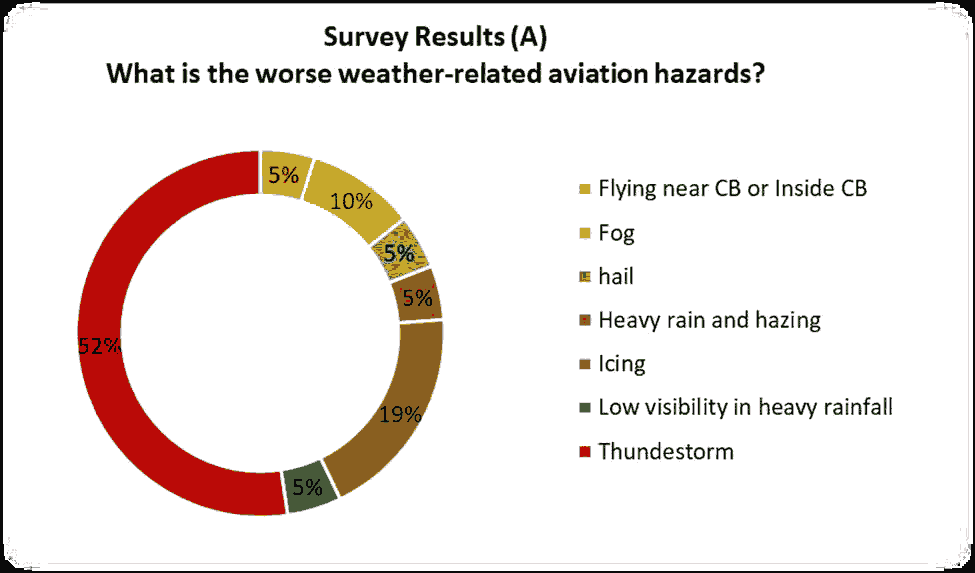
1. What is the worse weather related aviation hazards?
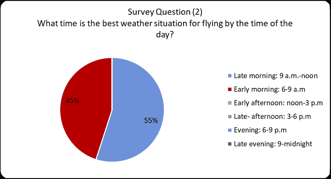
2. What time is the best weather situation for flying by the time of the day?
3. What is the Worst Weather Phenomena at Yangon International Airports?
Model B: Frequencies of occurrence of specified weather phenomena at specified times.
Analysis results from frequencies of occurrence of specified weather phenomena at specified times. Frequency is a measure of the number of occurrences of a particular score in a given set of data.
limatological table shows the mean percentage of occurrences of weather phenomena at YANGON International Airport for each month and season of the climatological period under review. Percentage is calculated by taking the frequency in the category divided by the total number of participants and multiplying by 100%.

The amount of BR, RA, FOG, SHRA, DZ, and TSRA weather phenomena was calculated for each month at 30-minute intervals, on the basis of which the frequency percentage of weather phenomena occurrences was obtained [TABLE 2.]. The following criterion was used for the weather phenomena climatological tables: If two weather phenomena are observed during the same period (00,30), then each value is inserted separately in the corresponding column (e.g. Rain Fog (RAFG). Yearly, monthly and timely frequencies analysis and climatological tables show correlation between yearly TSRA occurrences and El Nino, La Nina events for the period from 2009 to 2019 and performed trend forecasts. If two weather phenomena are observed during the same period (00,30), then each value is inserted separately in the corresponding column (e.g. Thunderstorm Rain (TSRA) and fog (FOG) go to the Thunderstorm Rain and fog columns accordingly; rain and thunderstorm (TSRA) - each value is inserted separately in the rain and thunderstorm columns, etc.). The “RA” Column includes both weak, moderate, heavy intensity rains (Cumulus nimbus) SHRA and rains (Nimbus stratus) RA.
Survey results Qualitative Survey Results and Accident Cases Study (Model-A)
This section presents the results of vital and online qualitative survey questionnaire about weather experience to aviation persons of worse weather phenomena for flight operations at VYYY and VYMD, and Case study of weather-related aircraft accidents at those airports.
1. What are the worse weather-related aviation hazards?
2. What time is the best weather situation for flying by the time of the day?
3. What is the Worst Weather Phenomena at Yangon International Airports?
As the result of question A, Thunderstorm is the worse whether phenomena with 52% results and Fog and Low Visibility condition is also the worse with 10% and 5% of answers result. Others answers are mostly thunderstorm related weather phenomena [FIG.3] [FIG.4].
Only Early and Late morning (6 a.m. to noon) are the best weather situation as the answers result. But late morning (9 a.m. to noon) can be also worse time during south west monsoon season due to the thunderstorm conditions as they answer.
Survey question 3 is asking about the experiences of weather phenomena at VYYY to pilots. As their experience, Rain on approach (20%) and Thunderstorm (18%) is the worst weather conditions at VYYY [FIG.5.]. Other weather also related with thunderstorm and low visibility weather conditions.
Causes of Aircraft Accidents at Myanmar
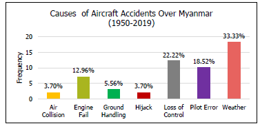
It is quite rare for an accident to be explained by one single cause. Almost every mishap is the consequence of a chain of events and accident reports usually discriminate between the main cause and a number of contributing factors. The [FIG.6.] shows the distribution of main causes identified in aircraft accident. The main root cause is weather related accidents. Also, some loss of control accidents may be unfortunate factors can result in aviation accidents, among an aircraft's greatest threats are the
Shannxi Y8F-200W accident at 7th June 2017
A Shaanxi Y-8-200F transport plane operated by the Myanmar Air Force impacted the sea during a flight from Myeik to Yangon in Myanmar. The aircraft carried military personnel and family members and had departed Yangon on a flight to Dawei, Myeik and Bokpyin and back to Yangon via Myeik. On its return, the aircraft arrived in Myeik at 11:55, and departed for Yangon at 13:06 local time. The aircraft climbed to FL180 and proceeded along the coast. It passed two areas with cumulonimbus clouds and the flight crew activated the wing anti-icing. At 13:31 hours an alarm was triggered, indicating engine air inlet icing. At the same time, while flying in the vicinity of another area with cumulonimbus clouds, cross wind increased from 8 knots to 42 knots [9].
In these conditions the aircraft stalled and entered a spin. The flight crew failed to recover from the spin and the aircraft impacted the sea.
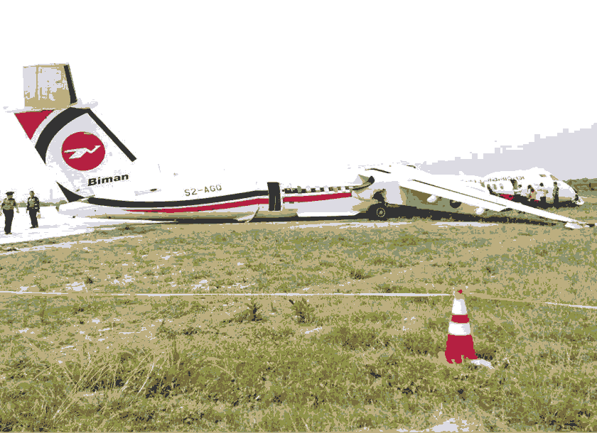
Biman Bangladesh Airline’s 8th May 2019 accident at VYYY
A Biman Bangladesh Airlines DHC-8-400 suffered an accident during an attempted landing on runway 21 at Yangon-Mingaladon Airport, Myanmar. The aircraft departed Dhaka-Shahjalal International Airport, Bangladesh, as Biman flight 060 about 15:15 hours local time with destination Yangon-Mingaladon Airport in Myanmar [FIG.7.].
Weather at Yangon was poor due to the presence of a thunderstorm in the area. The METAR weather reported at Yangon International Airport on the 8 that 12:00 UTC/18:30 local time was variable winds direction at 10 knots with Gusts of 20 knots, Visibility 3000 meters, Thunderstorm with rain, Broken clouds at 1000 ft, Few clouds at 8000ft, Temperature 30°C, Dew point 27°C and Regional atmospheric pressure 1003hpa. The METAR reported on the 8 that 12:30 UTC/19:00 local time was a wind speed 08 knots from 30 degrees, Visibility 4000 meters, Thunderstorm with rain, Broken clouds at 1200ft, Few clouds at 1600 feet above ground level, Overcast clouds at 10000 ft, Temperature 30°C, Dew point 27°C and regional atmospheric pressure 1004 hpa (Aircraft Accident Investigation Bureau of Myanmar, 2019).
While the flight crew was performing an ILS approach, the controller instructed them to go around as the airport was closed due to weather. When the weather condition got better, the flight was cleared for an RNP approach to runway 21 because only the localizer was available at that moment. The co-pilot was Pilot Flying and the captain was Pilot Monitoring. The aircraft was higher than the 3 degree approach path and the airspeed fluctuated between 136 and 151 kts, which was than the 122 kts target airspeed. The captain said "continue, continue" to the copilot and the approach was continued. At an altitude of 22 feet over the runway, the captain began pushing the control column forward, while the PF was attempting to pull on the control column. At 1828 m down the runway, with 1585 m remaining, the aircraft briefly skipped a few times before getting airborne again. The captain then stated: "I have control", which was confirmed by the co-pilot. While in the air, the captain applied the brake pedal several times. At a height of 44 feet, the captain put the propellers in beta range and reduced the power lever angle to 18 degrees. The aircraft sank again and collided with runway 03 and slid forward. It left the runway and came to a complete stop in the over-run area 2019).
The aircraft fuselage broke in just behind the forward passenger door and just behind the rear service door. The undercarriage collapsed and the right hand wing broke at the attachment point with the fuselage. There was no fire. All occupants survived, but twelve suffered serious injuries.
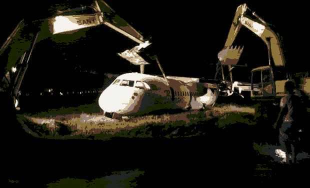
AirBagan ATR-72 accident on 24 July 2015 at VYYY
An ATR-72-212 operated by Air Bagan was damaged in a runway excursion accident at Yangon-Mingaladon Airport (RGN), Myanmar. Flight W9424 was a scheduled service from Mandalay to Yangon [FIG.8.]. The copilot was Pilot Flying, while the captain was Pilot Monitoring. It was raining as the flight approached Yangon with Cumulonimbus clouds at 1500ft over the airport. As per the special weather report (SPECI) at 12h15(UTC) was a wind speed 04kt from 320, visibility 4000 meters, Ra BkN 012, Few 015cb ovc 090, Temperature 25°C, Dew point 25 C,QNH 1010 CB. However, the aviation weather report system was semi-manual and the data transfer process was delayed. The duty ATC controller did not seem to notice the Special Weather Report (SPECI) immediately and the pilots did not receive it either.
When 4 km out, the flight was given landing clearance by ATC: "Air Bagan 424, wind calm, runway 21, clear to land, caution landing runway wet, after landed vacate via Charlie." At decision height (250ft), runway 21 was in sight and runway lightings were seen. The aircraft continued though there was light rain. At about 50ft, visibility suddenly became poor due to heavy rainfall. So the captain took over control of the aircraft. A few seconds later the aircraft made a hard landing, skidded and veered off the left side of the runway onto muddy ground. It came to rest about 2800ft from the threshold and 75ft from the runway edge. The copilot radioed a distress message, but did not use standard phraseology. The ATC controller did not appear to understand the message and was not able to give definite information and instruction to the Airport Fire Station to respond to the emergency. Therefore, the aircraft rescue and fire fighters reached the accident site after about 8 minutes. According to the final decisions of investigation board, it occurred that the pilot was reluctant to perform a go-arund while the plane was unstable and of bounce landing in low visibility condition during the final landing phase [10].
Statistical Analysis Results (model B)
As first evaluate the half hourly METARs data and count 119874 times of observation data from YANGON International Airport, thirty-minute (xx20, and xx50) METARs. Among these data, we got 20219 times of weather phenomena occurred including 1237 times of Thunderstorms occurrences. Then, we got frequencies percent of each weather phenomena including thunderstorms.
| Mean frequencies (percent) of weather phenomena occurrences By month |
|||||||
|---|---|---|---|---|---|---|---|
| MONTH | Weather Phenomena | ||||||
| BR | HZ | FG | DZ | RA | RAFG | TSRA | |
| JAN | 0.32 | 5.77 | 6.50 | 0.56 | 0.11 | 0.01 | 0.29 |
| FEB | 0.86 | 8.35 | 11.55 | 0.03 | 0.00 | 0.00 | 0.00 |
| MAR | 0.59 | 7.00 | 10.38 | 0.11 | 0.17 | 0.00 | 0.23 |
| APR | 0.02 | 3.03 | 2.83 | 0.25 | 0.09 | 0.00 | 1.01 |
| MAY | 0.02 | 0.99 | 0.73 | 2.34 | 1.41 | 0.00 | 5.70 |
| JUN | 0.01 | 0.27 | 0.27 | 6.78 | 4.51 | 0.00 | 9.83 |
| JUL | 0.00 | 0.41 | 0.52 | 9.74 | 6.49 | 0.00 | 12.13 |
| AUG | 0.04 | 0.56 | 1.00 | 9.20 | 5.22 | 0.00 | 10.79 |
| SEP | 0.03 | 0.96 | 1.23 | 4.95 | 3.05 | 0.00 | 8.31 |
| OCT | 0.18 | 3.47 | 3.82 | 1.83 | 1.35 | 0.00 | 4.74 |
| NOV | 0.09 | 3.34 | 3.30 | 0.62 | 0.47 | 0.00 | 1.38 |
| DEC | 0.21 | 6.01 | 4.51 | 0.10 | 0.03 | 0.00 | 0.13 |
Table 2. Monthly Frequency Percentage table of weather phenomena occurred.
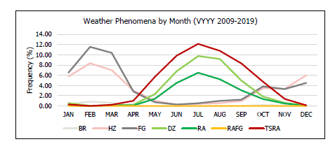
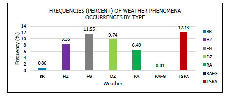
Maximum frequency occurrences for each weather phenomena are colored in table. Mist (0.86%), Haze (8.35%) and Fog (11.55%) are maximum frequency in February. For maximum Drizzle (9.74%), Rain (6.49%) and Thunderstorm (12.13%) are occurred in July during 2009-2019[TABLE 2] [FIG.9.]. There are three seasons in Myanmar-
1. Winter or Northeast monsoon season (November - February),
2. Summer or Hot weather season (March - Mid May) and
3. Rainy or Southwest monsoon season (Mid May - October) as by Myanmar Climate Report 2017[11].
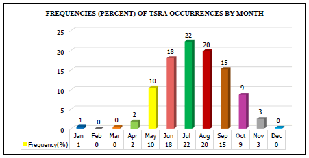
Fog and Haze weather phenomena are maximum occurred during winter. But Thunderstorms are occurred maximum during half of Summer and the whole Rainy seasons. As the result of Figure – 5, not less than 8 months had occurred maximum thunderstorm condition in Yangon International airport.
There have many significant impacts weather on the aviation industry such as snow, fog, thunderstorm, turbulence, and dust storm. Here in Yangon international airport, the maximum impact weather phenomena are Thunderstorms (TS) and Fog (FG) [FIG.10.].Thunderstorms had a more serious impact on airport operations due to the many related kinds of weather that followed such as, hail, strong winds, heavy rain, lightning, and severe turbulence. All of these are a high impact on aircraft operation and aerodrome operation.
As above mention, visibility is also an important factor in all phases of flight, but especially when the aircraft is maneuvering on or close to the ground, i.e. during taxi-out, take-off and initial climb, approach and landing, and taxi-in. Aircraft departure and arrival is limited by the visibility (or RVR) to an extent that depends on the sophistication of ground equipment, the technical equipment fitted to the aircraft and the qualification of the flight crew (Skybrary.aero, Visibility). For Yangon international airport, the visibility rang had 600 to 9000 meters during the thunderstorm (TS) and thunderstorm rain (TSRA) conditions. The maximum occurrences value is around 5000 meters with 41.97% frequencies. And the minimum value is 600 meters only with 0.02%. If doing averaging all values, visibility will be 3500 m with 6.67% on average from 2009 to 2019 [FIG.11].
For monthly analysis of thunderstorm occurrences during these 2009 to 2019 period, frequency occurrences percentage are as following in figure-8. That maximum frequency is 22% in July, minimum frequency is 1% in January and no occurrences months are February, March, and December with 0%. According to the seasonal distribution, July is the Rainy season. Normally thunderstorms in the Rainy season are usual. But during winter and summer, the main factor of thunderstorm occurrences is the tropical cyclones from the Bay of Bengal or Western Pacific [12].
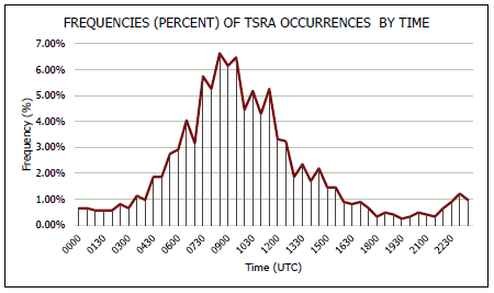
For daily analysis for TSRA during these 2009 to 2019 period, frequency occurrences percentage are as following [FIG.12,13]. Maximum frequency of TSRA weather may occurred 08:30 UTC to 10:00 UTC during a day. Minimum frequency may occur 19:00 UTC to 2000 UTC. According to time zones, 08:30 UTC will be local time will be 15:00 afternoon. Thus, maximum TSRA occurrences may be occurred between 15:00 UTC to 16:30 UTC afternoons in those TSRA days at Yangon international airport. For the aviation purpose, 00:00 UTC to 04:00 UTC is the better time for daytime operations in those TSRA days.
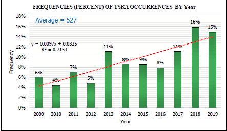
Yearly frequencies analysis showed how TSRA days occurred more than year by year clearly. During these eleven years, minimum occurrences are 255 times in 2010. For average occurrences are 527 times and the maximum occurrences in 2018 with 920 times [FIG.14.]. The trend forecast showed positively increasing thunderstorm occurrence in future and regression value of this trend is strongly (R2>0.7).
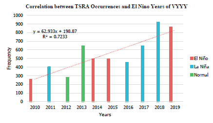
Myanmar and Yangon International airport is located Western Pacific tropical region where the directly impact area of El Niño/La Niña events. So, we performed correlation analysis with El Niño/La Niña events by yearly [13].
As the analysis result some occurrences amount had a relationship with El Niño/La Niña events. Even these El Niño or La Niña events, the trend of TSRA occurrences is up or increase year by year. So, we can assume that any El Niño or La Niña events does not concern with that increasing trend. As the trend forecast results, generally in the future TSRA days will increase at VYYY. This forecast is strongly by R square also strong like yearly analysis (R2>0.7) [FIG.15].
Summary
As summary, airports are the vital national resources for every country over world and safety of each aerodrome are key role play for aviation industry. Among the many factors of aerodrome safety, weather is the uncontrollable factor with highly impact on aircraft and aerodrome operations.
This paper will first examine the impact of aviation climatology on these airports. And a statistical analysis of the observations data obtained by each meteorological stations. It is also intended for a wide range of users:
• international and domestic civil airlines which conduct flights to/from MYANMAR airports;
• private pilots;
• operational and administrative services of airports;
• aeronautical administration;
• air navigation services providers;
• The MYANMAR Civil Aviation Agency.
Besides the above-mentioned potential users, this Summary can also be used by specialists from other domains for the purposes of scientific research.
The first research objective is to provide a fundamental analysis of the impact of specific weather phenomena on the performance of an airport. The following research questions arise from that:
• To which weather risks and hazards are exposed in these airports?
• How sensitive are aviation operating systems to these hazards?
• How and how much do the pilot and aerodrome operators faced these climate hazards?
• Which needs for overcome do they delay operation?
As the result of analysis, in July we can be faced many Thunderstorm days every year. Maximum TSRA occurrences may be occurred between 15:00 UTC to 16:30 UTC afternoons in those TSRA days at Yangon international airport. Thus, for the aviation purpose, 00:00 UTC to 04:00 UTC is the better time for daytime operations in those TSRA days and visibility will be 3500 m with 6.67% on average. Even non-El Niño/La Niña years, TSRA occurrences is up or increase year by year as the trend forecast results. Generally, in the future TSRA days may increase at VYYY. So, for the important operations we can be managing each operation requirement by time. That highly risk operations should be carrying out less TSRA months. Finally, the distributions provided in this paper could allow airports and airlines operators to forecast the average TSRA days at the infrastructure as a function of the current and forecast weather in order to apply mitigation strategies.
Acknowledgment
The researcher expresses special thankful to all Professors from whose approve and support to this research and Nanjing University of Information Science for support to come out this research especially to the Ministry of Commerce of the People's Republic of China to give me the opportunity of this Master Study at China.
I would also like to extend my gratitude to the Department of Meteorology and Hydrology for support data of Myanmar, Prof. Larry Oolman from Department of Atmospheric Science, University of Wyoming, United States, who support METAR data for airfields and special gratitude to Professor Badri Jijelava, Head of met office at SAKAERONAVIGATSIA for support research idea and analysis techniques.
Finally, special thankful to Prof. Wang Wen from Nanjing University of Information Science and Technology, for supervisor this paper and his others support during this research.
References
- Bureau of Transportation Statistics. 2019. Delay Cause by Year, as a Percent of Total Delay Minutes. Bureau of Transportation Statistics. 2019.
- Aircraft Accident Investigation Bureau of Myanmar.
- Tailwind Operations - SKYbrary Aviation Safety. n.d. Accessed November 22, 2020.
- FAA. 2016. Approaches and Landings. Airplane Flying Handbook.
- Ong Chao Choon, Myanmar Business Guide. PricewaterhouseCoopers Myanmar Co., Ltd. 2012.p1–38.
- Dorian, Reece, and Toby Robinson. 2018. IATA Guidance Booklet: Airport Ownership and Regulation.The World Bank/ Public - Private Infrastructure Advisory Facility. 2018.
- ASN Aircraft Accident de Havilland Canada DHC-8-402Q Dash 8 S2-AGQ Yangon-Mingaladon Airport (RGN).n.d. Accessed November 23, 2020.
- Technical Regulations. In: Kaplan D.M. Encyclopedia of Food and Agricultural Ethics. Springer, Dordrecht.2019.
- Technical Regulations, Volume II – Meteorological Service for International Air Navigation (2018 edition, Updated in 2020).
- Final report of runway excursion accident of air bagan. 2015. 72 July:1–23.
- Kuleshov, Yuriy. Thunderstorm and Lightning Climatology of Australia. Modern Climatology. 2012.
- Lo, Vera. Weather Index Project: Investigating the Effect of Weather on Flight Delays. September.2013.
- Zin, Ei Ei, Aung L, et.al.. Myanmar Climate Report. Norwgian Meterological Institute. 2017.105.
