Original Article
, Volume: 5( 3)The Square Mesa and Related Formations
- *Correspondence:
- Orme G , School of Engineering Science, Undergraduate Science Student, University of Queensland, Brisbane, 4000 Australia, Tel: 07-33656195; E-mail: gregorme@gmail.com
Received: September 11, 2016; Accepted: November 30, 2016; Published: December 30, 2016
Citation: Greg M. The Square Mesa and Related Formations. J Space Explor. 2016;5(3):106.
Abstract
The Square Mesa and related formations are hypothesized to have been islands in a paleosea that lasted over 1 Ga. Similar life compatible geology may exist to that found by the curiosity Rover in nearby Gale Crater. The biotoxicity of Martian soil should have allowed for life to evolve in this area, lithopanspermia may have allowed for microorganisms such as lichen to be transported from Earth to Mars into this paleosea. The wall like shapes on these formations occur only on some islands but not on others close by in the same geological conditions and processes involved in their creation. The Square Mesa shows signs of bricks of the same size repeating, also layers of constant thickness.
Keywords
Square Mesa; Lacustrine; Aeolian; King’s Valley; Paleosea; Biotoxicity; bricks; Elysium Mons
Introduction
The Square Mesa is a pyramid shaped formation in Elysium Mons discovered by the author. Also, shown here are similar formations, they generally have a sandy interior surrounded by a wall like casing possibly composed of rocks, bricks, cement walls and other similar shapes.
There is considerable evidence that these formations were surrounded by water in an ancient paleosea. Ivanov et al. found that Utopia and Acidalia Planitiae have indications of the former presence of large reservoirs of water and mud [1]. This is shown by them using impact crater ejecta morphology, in the areas of the former paleosea these become pancake like. Etched flows are considered to be from mud and are found around this pancake ejecta. The age of these reservoirs is estimated to be 3.57 Ga in Utopia Planitia and 3.61 in Acidalia Planitia.
In Orme and Ness (2011) it was hypothesized that a very shallow meteor impact formed the Argyre Crater, this would have directed the shock wave towards the south pole situated at the time around the future Tharsis Montes [2]. The melting of this pole would have caused flooding and lakes in Valles Marineris and Chryse Planitia extending up into Acidalia Planitia. This would have caused antipodal volcanism with Elysium Mons, Hecates Tholus, and Alba Tholus. Since the current north pole would have been in this area it would also have melted created a paleosea in Elysium Planitia, Utopia Planitia and perhaps extending to connect to the paleosea in Acidalia Planitia. This impact could have had two causes, intentional or accidental. One hypothesis is that aliens visited out solar system around 4 billion years ago, to terraform it and seed it with life. The second hypothesis is that this impact hit the pole by coincidence and created a long lived paleosea that allowed primitive sentient life to evolve and then die out. Ivanov et al. suggest that this was a single ocean in the Northern Plains, however these two paleoseas warmed by volcanic activity may not have joined up or they could have later separated [1]. This hypothesis is testable if the paleosea evidence is stronger around these two former poles with fewer signs of a water ocean between them.
Discussion
Plescia examines Cerberus Fossae, a fracture system found in the south-eastern area of Elysium Planitia [3]. This would have acted as a conduit for lava and water into Elysium. This water release would have occurred in Athabasca and Grjota Vallis in the north west, and in Rahway Vallis in the south west. According to Orme and Ness, this water would have come from the melting pole in the area, the heat caused by the antipodal volcanism forming Elysium Mons and the increased air pressure from the frozen gases at the poles would have caused floods and atmospheric precipitation [2]. This would charge groundwater reservoirs causing sapping as well as rain forming these fluvial valleys seen in Elysium Planitia and Libya Montes. This would also have formed the King’s Valley which it is proposed contains possible artifacts, it drained into Elysium Planitia as discussed in Orme [2]. Sprenke and Baker discussed a pole in this area from fitting paleomagnetic pole positions in eastern Valles Marineris as the opposing pole, and another around the Southeast slope of Elysium Mons [4].
According to Plescia, this water was released catastrophically and non-catastrophically from this location close to the King’s Valley [3]. It connects then to the proposals of this ancient paleosea being adjacent to the King’s Valley for a billion years, in Orme [2]. This fluvial system extends for more than 2500 km across the Cerberus Plains through Marte Vallis and into Amazonis Planitia. Orme and Ness proposed the Argyre impact created the Tharsis Montes and Olympus Mons on the former south pole, this floodwater from the melting pole would also have drained into Chryse Planitia along Valles Marineris and in the current west direction into Amazonis Planitia [2].
These paleoseas would have remained liquid from the volcanic heat as Elysium Mons, Olympus Mons, and Tharsis Montes rose. Because they would have been on the current poles this would have created weather patterns including Hadley Cells as colder air was drawn back to the poles then reheated by the volcanoes. This would have led to a continuing series of floods, groundwater recharging, and atmospheric precipitation of rain and snow. Plescia assesses this flooding to have occurred in the late Amazonian when these proposed artefacts were formed [3]. The Square Mesa and related formations would then have been islands in this paleosea. The hypothesis is these were formed around sandy islands by shoring them up with rocks, bricks, etc. around their sides. Some may also have been formed by dredging sand out of this sea. According to Plescia, the Cerberus Plains are the youngest volcanic surface on Mars, however, in Libya Montes the terrain is Noachian and among the oldest [3]. According to the impact hypothesis the resurfacing of the Cerberus Plains would have occurred from the effects of the Argyre impact and the subsequent antipodal volcanism.
Kossacki et al. discussed a possible Martian paleolake in southern Elysium as recent as the past few million years ago. They assess this timescale because of the pristine features, however much of this depends on whether variations in the Martian obliquity would have periodically caused melting on the poles, and then a rise in air pressure [5]. However, the obliquity hypothesis is used to explain the fluvial valleys such as Athabasca Vallis in Elysium, instead of this the Argyre impact hypothesis would have this floodwater coming from the melted pole. This would have created a paleosea lasting a billion years with remnant paleolakes lasting longer as the sea sublimated. The northern ocean then would have been formed from this impact, it melted the poles but as Tharsis, Elysium Mons, and Olympus Mons cooled this would have sublimated back to the poles as they wandered according to the path suggested by Sprenke and Baker [4]. Later changes in obliquity might then have not caused substantial flooding and rises in air pressure. This would also allow these possible artefacts to survive for billions of years if the air pressure did not allow for substantial erosion. It allows for some falsification of the artefact hypotheses if these formations could not have survived this regular change in obliquity and increased erosion.
Kossacki et al. also investigates whether there is remnant ice from this paleolake, there could also be ice remaining from the former pole [5]. This paleolake then may have been part of the pole, it would have become a lake from the heat of Elysium Mons, then solidified as ice to be sublimated as the atmosphere froze. HiRise images show platy deposits resembling ice covered Earth seas, seen in Figure. 1.
Their work is consistent with this hypothesis of a former pole; they test whether a frozen mud lake remained after this long term sublimation of the larger frozen paleosea. Fine grained sediment would form an ice and dust mixture allowing some of the ice to be buried with continuing sublimation. This ice deposit is considered to have been tens of meters thick, it would then be consistent with the Square Mesa and other formations which would have been constructed in a shallow paleosea. If this ocean then was very deep in this area then the hypothesis would fail, the island like formations would have been underwater with no need for shoring up their sides. The platy formations in Figure 1 would have a similar thickness to this paleosea depth around these possible artefacts.
Kossacki et al. suggest that this regolith layer of original lake sediments has a thickness of 5 meters to 50 meters [5]. It may be the Square Mesa and related formations are partially buried with this much sediment, the actions of this sublimation may have been similar but there are no platy deposits around them. This suggests the paleosea may have been warmer and more ice free nearer to Elysium Mons and that this was controlling much of the evaporation and sublimation of the water. Kossacki et al. use the analogy of pack ice flows and the clear water between them, closer to Elysium Mons this would have been less common [5]. Much of this paleosea may have been covered by a fine layer of dust or volcanic ash as it froze, this may mean there are large deposits of ice still under Elysium and other parts of the Northern Lowlands. They suggest that the ice would have sublimated from this sediment in approximately 4000 years. It is suggested in Orme and Ness that this original impact at Argyre Crater could be replicated by us, aiming a shallow meteor impact the current north pole might flood the Northern Plains recreating this paleosea [2]. A similar impact on the south pole might fill Prometheus Basin and Hellas Crater with floodwater as the poles melted, also the frozen air on the poles would sublimate creating higher air pressure and a weather system around these volcanoes as would have occurred with Tharsis and Elysium Mons approximately 3.8 Ga ago. In that case, much of the Northern Plains might have ice trapped in this regolith and rejoin these oceans.
Balme et al. also examine these platy deposits, Athabasca Valles is suggested to originate from the Cerberus Fossae, kilometer wide fractures perhaps related to the formation of Elysium Mons [6]. The pole then may have melted preferentially around these Fossae causing these floods, they would be similar to fractures around Tharsis Montes that are also related to flooding from that pole. Some have suggested these platy deposits are flood lavas not paleosea deposits, the authors find no relation to vents and conclude the platy deposits were sourced from the Cerberus Fossae and were transported down Athabasca Vallis. Mapping of rubble piles also appears to have been transported from Athabasca Vallis.
This is also consistent with the Argyre impact hypothesis and the subsequent rise of Elysium Mons melting the pole and forming these Fossae, ice would have melted around them and then been transported down Athabasca Vallis filling this paleosea in Elysium. This area also has MOLA grid slopes of less than 0.05° implying a level surface of water. It also implies that the surface of the platy terrain has dropped by tens of meters, this is again consistent with the elevation of the Square Mesa and related formation using walls of about this size in this former paleosea. As the water sublimated then the terrain would also have dropped around these possible artefacts leaving them higher above the flat terrain of the former paleosea. The edges of the basin are also seen to be tens of meters higher than these plates implying this amount of sublimation and settling, some plates have grounded on top of obstacles and remain connected to margins like land-packed ice. Murray et al. calculated a depth in the basin of 31 meters to 52 meters [7]. By analyzing inundated to unbreeched craters they found a rim height range of 41 meters to 65 meters. Some inundated craters formed closed basins implying the lowering of surface through sublimation.
Platz and Michael discussed the eruption history of the Elysium Volcanic Province, how volatiles released in these eruptions greatly increased the density of the Martian atmosphere [8]. This is consistent with the hypothesis of the Argyre impact melting the poles, the volcanic outgassing would have continued for under 200 ma. They model the lava flows in Elysium that range from 3.4 Ga consistent with this impact. They then suggest that continuous volcanic activity occurred with a peak at 2.2 Ga, consistent with a paleosea in Elysium Planitia, Utopia Planitia, and Amazonis Planitia remaining liquid because of this. Further away from Elysium Mons the platy deposits are found implying the paleosea became colder forming pack ice. On Earth this occurs approaching the poles, on Mars this may have occurred moving further away from Elysium Mons, Tharsis Montes, Alba Patera, and Olympus Mons. According to them this volcanic activity rapidly waned 1 Gya ago, this may have led to the paleosea freezing and sublimating.
It is possible then from this evidence that a paleosea existed in this area for up to 2.6 billion years, if so then it may have been long enough for sentient life to evolve. Exchange of genetic material with Earth may have also occurred with panspermia, this time of greatest activity by Elysium Mons would have coincided with the evolution of eukaryotes or celled organisms with a nucleus on Earth. More advanced life on Earth occurred in the Cambrian Explosion about 542 million years ago, and the dinosaurs about 231 million years ago. There is then a disparity between the time this paleosea existed and the evolution of life on Earth but a long evolutionary period on Mars is supported to some degree by the evidence.
In Orme and Ness, it was hypothesized that polar wander occurred after this initial Argyre impact following the path of Sprenke and Baker [4], the south pole would have stabilized at a position west of Hellas Crater. This corresponds to a great circle or equator on which 4 main possible artefact clusters are found, namely Nefertiti, Cydonia, the Ferns, and the King’s Valley.
Initially then Elysium Mons would have created this paleosea from the former north pole in Utopia Planitia, then this area moved to the equator allowing the paleosea to remain liquid for much longer. This paleosea would also have extended to Chryse Planitia which would have also been in this equatorial zone, alternatively the two paleoseas may have been disconnected with Cydonia Mensae approximately between them. Acidalia Planitia would have been further away from all these volcanoes and the equator, and so would likely have frozen first as it contains more of these platy deposits.
Morris and Mouginis-Mark find that evidence of volcano-ground ice interactions give insights into the timing of these volcanic processes and their effect on climate [9]. Hrad Vallis is an 800 km long fluvial valley that it has been suggested was formed by an explosive magma-ice interaction. This would be consistent with the Argyre impact hypothesis where the rise of Elysium Mons on the pole created this valley from floodwater. They identify 12 craters with signs of an interaction with hot mud flows and ice. The lobate deposit that Hrad Vallis originates from is suggested to be a mudflow, however it also has more craters on it than the underlying unit. This may be because the underlying terrain was still covered with polar ice for a long period. Fluvial valleys like these would have fed the paleosea, this is close to the Square Mesa and other formations.
Balme et al. investigate Martian stone circles in Athabasca Vallis and find they could only have formed in a periglacial environment [6]. Domed and ridged polygons in the area have also been interpreted to be periglacial. It is considered to be unusual that these sorted stone circles are found near the current equator, however this periglacial environment could have been associated with the former pole and the later icy paleosea. They imply a Martian climate that was 40 Kelvin to 60 Kelvin higher on Mars than the present and that supported a sustained freeze and thaw. These are shown in Figure. 2. They are different from thermal contraction polygons found elsewhere on Mars that require only temperature changes. Climate models of different obliquities and temperatures offer no resolution to this problem, this also implies that these fluvial signs are more likely to have come from this volcanically active time rather than regular changes in obliquity since then. They suggest several hundred seasonal cycles or Martian years would be needed to form these stone circles. Because these are found in the flood plains of Athabasca Vallis they are more likely to be the source of the ice and the particulates required. Near-surface ice and liquid water must be preserved for enough time for these polygons to form, hence the several hundred Martian years suggested. Similar landforms have also been described across the Cerberus Plains up to a 100 km away, they support a regional warming of the climate. This could then be from the nearby volcanic activity while other areas of Mars would have remained much colder.
Viking spiders
Some additional evidence for a pole in Utopia and Elysium Planitia are the Viking Spider formations discovered by the author. These are similar to the spiders found at the current south pole. In Figure. 3 these are shown to be close to the Viking 2 lander hence the name.
The characteristic spider shapes are shown in Figure. 4. Because much of this area was a paleosea only a small section of the polar terrain containing these spiders may have survived. Ness and Orme proposed these spider shapes were formed by CO2 gas being expelled, however this had the problem of how to explain the branch shapes forming [2].
Prieto-Ballesteros et al. investigate these araneiform or spider formations on the south pole. They propose these form from the seasonal melting of salty solutions under a transparent ice layer [10]. Piqueux et al. suggest that abrupt expulsions of gas explain the fan shapes around the emission center, but they do not explain the carved branched pattern [11]. This CO2 jet hypothesis requires spiders to be in the cryptic region on the south pole, this would be analogous to the area near Viking 2 as shown in Figure. 5. Balme et al. [6] discuss polygons in this area of Elysium, my proposed hypothesis is these spider shapes are formed by the expulsion of CO2 gas along the polygonal fractures as shown in Figure. 6. Figure. 6ashows the spider pattern from tracing out a path from a centre where CO2 gas would be sublimating, this would be covered by transparent ice and heated by the spring sunlight. Figure. 6b shows a similar spider pattern on the Martian south pole, the dark dust would be pushed by this CO2 or a brine along these polygonal fractures forming the same pattern as in Figure. 6a.
Freeze thaw and thermal contraction polygons are common on the current south pole and would form the pattern shown. The sunlight in spring through a transparent ice layer would sublimate CO2 gas causing it force its way along the polygonal fractures creating the branched pattern. Ness and Orme showed how polygons are always found near spiders but virtually never next to them [2]. It implied that the spiders would be formed either in a similar way to polygons or formed from them. Spiders are also found in a narrow strip on the edge of the pole, this may be where the spring sunlight is warm enough to force the CO2 gas to open these polygonal fractures. Closer to the pole this sunlight may not sublimate enough CO2 and further from the pole it may instead cause a CO2 geyser.
Prieto-Ballesteros et al. [10] propose the seasonal changes in temperature on the south pole melt briny ices, Piqueux proposes CO2 gas is released without brines [11]. These spider areas according to both would be covered by an ice layer, the sunlight reaches the CO2 and/or briny layers causing sublimation and melting creating the spider channels. In some cases, this CO2 gas or brine would be ejected from the ground and dispersed like a geyser on the surface. Neither however has an explanation for the branched shapes.
Elysium, Utopia, Isidis, and Amazonis Planitias have considerable evidence of containing a paleosea for a billion years or longer. Because of the evidence in the King’s Valley Libya Montes it is an additional hypothesis that this paleosea contained islands with possible artefacts as well. A logical mode of construction would be to create sea walls around them using rocks or bricks as we would do on Earth. These formations are presented according to this hypothesis. Figure. 7 shows a cluster of these former islands with wall like shapes around them, it is proposed the heat from Elysium Mons, Hecate Tholus, and Alba Tholus as well as Olympus Mons to the east kept this area of the paleosea more liquid. The null hypothesis is these wall-like shapes are random or natural geological processes, there is the intention therefore of falsifying this null hypothesis by showing how they differ from other natural former islands.
Figure. 8 shows the Square Mesa, the hypothesis here is that it was formed around a natural island or the sand was dredged up above the waterline. Then these walls like shapes would have been added to the sides to prevent subsidence and damage from wave action. There are few signs of actual buildings so a further hypothesis would be these were made of perishable materials.
The ecosystem would have been based on fishing and perhaps some sea vegetables, the King’s Valley shows possible murals of fish as shown in Orme [2]. Life on Mars at this time may have evolved or as a second hypothesis it may have been introduced as a terraforming mission perhaps by a visiting alien probe. Haynes and McKay [12] discuss how we could terraform Mars in its current state, they call this process ecopoiesis or the “making of an abode for life”. A hypothetical probe then might have faced a similar challenge to what we do today. The proposals in Orme and Ness [2] can offer some insight into how this terraforming may have occurred artificially or by accident.
Haynes and McKay identify the cold as a major problem, but that Mars has substantial quantities of the materials needed for life [12]. They also suggest planetary engineering to warm the planet, release carbon dioxide to thicken the atmosphere, and to release water. If there are no indigenous life forms, there then biological engineering would tailor it to these new conditions. The hypothesis then is that this same process that we intend to do was already done by visitors, or that with indigenous life there already a chance impact created a long term habitable climate. As described in Orme and Ness [2] this shallow meteor impact at the pole may have accomplished the goals outlined by Haynes and McKay.
The Square Mesa was discovered by the author and presented to SPSR, the Society for Planetary SETI Research of which I am a member. The consensus was that this formation had some merit, and that it was a prediction that when reimaged it should look more artificial and less explainable by this null hypothesis of natural geological processes. This was recently done by HiRise. Figure. 9 shows a close up of part of the Square Mesa wall, it appears to contain layers as shown.
Figure. 10 shows more layers in another part of the wall, these appear to be of a constant thickness and are horizontal as might be expected from construction with bricks. It is highly eroded and so if artificial it would be ancient.
Figure. 11 shows more layers in the Square Mesa; this are more of a step like configuration like flat plates of rock. It gives the impression then of the same kinds of bricks or stone blocks mounted in three different ways. Figure. 8 shows how the central area is much more amorphous, these layers appear to only be around the outer edge. Layers can form a complete landform but it is harder to explain how geological processes could surround a sandy hill like this.
Figure. 12 shows more layers. They appear to be more covered with sand, the actual blocks show little erosion. These layers seem to have a constant difference between them on the slope rather than being random.
These continue all around the formation as in Figure. 13, all horizontal. Again, the distance between them seems to be the same.
Separate blocks of stone may be visible here in Figure. 14. The central block with the small crater is very distinct. It is about the same size as the block directly below it. It appears then the same size blocks might have been used here.
This shows sand spilling over the top of the layers in Figure. 15, as if a broken wall is allowing the stored soil to come out. This is hard to explain as a natural formation, how this sand would get inside a hollow set of layers of stone blocks. Also, the layers appear to continue under this sand spill as if they are the same layers.
More layers in Figure. 16, these follow a curve in the shape. Similar layers are discussed in Orme [13] “Martian dams: artefacts or natural formations?” found in some craters. The walls here can then be a similar construction, here they hold in sand rather than water in a dam. It was also a prediction that these layers in the possible dam formations would be a recurring motif for constructions elsewhere, if not random.
A corner of the square mesa is shown in Figure. 17 with concentric circles as grooves in the rock. These layers can then form straight lines and also curves. It would seem to be like curved sections of brick forming these curves, this is a common motif in the possible dams in craters that have this curved shape as well as some with visible layers. Another possible construction method would be forming layers of concrete, letting them dry, then molding another one on top. A similar idea could have been used in the dams as this would reduce cracking between stone blocks allowing spills. Cement would be easy to make on Mars as discussed in the dam’s paper, the materials are readily available.
Figure. 18 shows a channel out of the Square Mesa like soil has broken open part of the wall. It is difficult for this sand to get inside this formation naturally, then erode its way out. It also shows the material inside this wall is much softer like sand, it appears to have come from over the top of the wall while other parts of the wall have a relatively constant amount of sand on them.
In Figure. 19, there is a nearby formation that seems to have a wall of constant thickness around it. It may also be a band of concrete with a constant height cast into a curved shape, possibly like in the dams. This also appears to have sand inside it, making it difficult for a layer like this to form around this sandy centre.
Figure. 20 shows layering in the crater wall that should not exist according to how craters are made. When they are formed by an impact any stone formations are usually pulverized. The crater walls are then made of this ejecta. Two layers here appear to have the same height along them.
Figure. 21 shows more layering in the crater wall, it appears to be like horizontal layers getting narrower towards the top. These could then be poured concrete in layers, then another narrow layer poured on top. The top layer is also very flat but a crater rim is usually rounded. It appears as if layers can be traced from one side to the other. A crater might have been used as a dam or pond for fish, an impact should not be able to produce these layers going right through both sides of the rim.
Figure. 22 shows how another crater has its walls built up asymmetrically. An impact should form a rounded shape. This is not the right shape for a crater to be formed by a shock wave on impact, however no layers are visible so it may be natural.
Figure. 23 shows more layers in the Square Mesa. The detail in the HiRise image shows virtually all of it has some layers around its sides. The middle layer appears to be of constant thickness along it.
Figure. 24 shows layering in the upper part of the crater, also on the formation on the right. This concave area of the right formation shows very similar distances between the layers. It seems to be a very common feature of these, it can occur in some natural layers but here these do not extend into the islands they surround. Sometimes then a hill might have formed completely of layers with a constant thickness, this can be eroded down into hill shapes looking like steps. However, in this case there are many islands and hills with no layers, then some with this casing of layers around them.
Figure. 25shows a wall like shape surrounding some mounds on the left. There is other very similar mound son the right but without a wall around them. Similar geological processes should have produced both sets of mounds, however the wall does not seem to have altered them when forming if it was natural.
Figure. 26 shows a wall shape all along this formation. This wall is particularly wide and goes over the side of the crater on the right. This is not a water level as it goes up the outside of the crater and inside, it cannot then have been formed by regular wave action. A geological process should not be able to form these wall shapes outside this hill and then merge into one inside a crater rim. Because a crater is formed by an explosive impact this wall shape must have formed afterwards. This is shown by A where the wall goes into the crater. Some eroded areas and craters show smooth soil under this wall. There are also some vertical cracks in these walls.
In Figure. 27 on the bottom there is no wall around the island, if natural then the wall should have formed all around it. The vertical cracks seem more evenly spaced as if blocks are separating, on the right this is combined with the layers appearing.
In Figure. 28 the walls have a different albedo to the rocks like they are a different material, here the hill on the left is lighter and sandier looking. Many of these formations have different possible ways of being created, a crater is formed in a different way to an island or a mesa. But all seem to have this same kind of wall material with similar angles. It would be hard to measure but the shadows imply these angles are very similar throughout the area unless the island shape is steeper. The surface appears more mottled here perhaps from individual bricks.
Figure. 29looks like a sandy hill or scooped up soil buttressed by the beveled wall around it. It appears more concave at the top like the sand has been blown away to some degree. On the upper part of the image the wall is more complete, this shows how it degrades going downwards. The middle of the wall seems to disappear allowing a concave area to form. It appears then like soil was being held in and was lost when the wall broke. The bottom of the image shows little or no wall on this side, it appears like a sandy island that formed without this wall making process. It is a recurrent motif for these walls to form on only one side more exposed to the paleosea, on other islands there is no wall at all.
Figure. 30 shows around the middle the wall is much wider indicating it is not caused by water erosion. It does not follow a possible water level. The right side of the island appears to have more soil between the rock peaks than it normally should, like it is being held in there by the walls to make a smoother surface. In many areas layers appear in this wall, also some vertical cracks like between blocks. The bottom of the image shows no wall, a geological process forming this would have to account for its absence on some sides of these islands.
In Figure. 31, the inside soil might have been washed out of this just leaving the wall. It is a similar walled material but with nothing inside it, the same geological processes would have to create free standing walls as well as the sides of these hills. If the hill inside eroded away then it would have to leave the wall not eroded, also this wall is about as well preserved as many others with interior hills and soil. The wall seems to have broken up into blocks or perhaps cracked pieces of concrete. The hill on the left is similar to many others in this area yet has no wall, a geological process would have to create a wall on some hills and not others.
Another wall with soil inside it is shown in Figure. 32. Compare this to the previous image, the formations are very different but the walls are similar. The hill on the right has no wall around it but both appear to have been formed with the same geological process.
In Figure. 33 there is a cigar shaped island with these walls around it. The craters show how the wall material is thin. The groove in the top has a straight edge, others are found in this area with similar grooves. This may then be a flat platform created on top of these walls.
In Figure. 34, this wall may have kept water out of a depression like using a dyke. The same geological processes that made walls around islands would have to produce free stranding walls like this and around hills. It has a mottled appearance like the wall has broken up into smaller rocks.
Another wall extending from a hill, acting like a dyke, cutting off water from a much larger area in Figure. 35. This has broken through in the middle of the image.
This much longer wall in Figure. 36 would also keep water out of between the mounds like a dyke. It could have been like the Netherlands, making larger walls in some areas to keep the sea out. Many layers can be seen.
Parts of the walls in Figure. 37 show layers like some of the Martian dams, they may be similar materials. The rounded corners are similar to one the square mesa with a series of concentric arcs. These layers then form any shape as if made of bricks and perhaps cement. The bottom right corner is like a corner of the Square Mesa. The bottom left side appears to have no layers, the island here looks like it is eroded and cut by wave action. The same geological processes should form layers all around the island.
This shows a large central depression in Figure. 38, it is surrounded by the same kinds of walls as on the left. There is no change in the wall structure between the two, to occur naturally this wall would have to form on the hill and then form a ridge to seal off this depression. There is a small island above this but it appears to have no walls, though it should have formed the same way.
Figure. 39 is similar looking to the Square Mesa in the middle island, the right formation appears to have this wall going right over its middle at A. The rest of this island is similar to the one on the left but has no wall, though it should have formed the same way. The middle island on its top shows vertical cracks in the wall, at the bottom this has broken up completely or never existed. This has left some rocks at B which appear to have rolled down from this gap, they may then have made up part of the wall. The left island also has this wall around the upper side but it is either eroded away or never existed on the bottom.
In Figure. 40, there seems to be soil packed in between the hills to make a more level surface. This might have been to make dwellings more stable. The layers are clearly visible on the right and some stones are protruding like they were part of the wall.
The wall has eroded away at the bottom of Figure. 41, soil appears to be spilling out or it was never there. The same geological processes should make this wall on all sides. The upper part of the wall seems to be in better condition, much of the erosion seems to have occurred more on the southern sides of these formations. It may be north of here the sea was much shallower and did not extend far. With a large bay to the south there may have been more waves, also a sea breeze from the temperature differences of the land and sea would have created more waves and eroding wind.
The soil appears to be spilling out of the left side of Figure. 42 where the wall has disappeared. On the bottom side the upper layer is very clear, then this has largely disappeared below it. Another example of this southern erosion.
This wall in Figure. 43 has a wavier shape with layers on the left. This may have been another dyke wall protecting low lying areas.
The wall on the right has practically disappeared in Figure. 44, it shows how thick it may have been. Some jagged edges stick up at A as if made of concrete, it seems to have broken in angles perhaps showing stone blocks. On the left of the image large parts of the wall are missing or buried.
A broken wall showing layers in Figure. 45. The upper side at A appears to have broken in two as one piece moved down its slope to the right. At B, the top of the layer seems to have stayed in place while the layers under it collapsed.
The wall in the middle at C is quite thick in Figure. 46, it seems to be holding in soil meant to level up the ground between the mounds. The red lines are a HiRise image of this formation. This wall may have been shielded from this southern erosion, perhaps from waves. Wind erosion is less likely as it should have worn down the hills as well. A and B are much more eroded as if waves might have come in from the upper right but not hit directly at C. This kind of erosion can give clues to the ecosystem and weather of the time.
These next images show HiRise images with the same features south of here starting with Figure. 46a. There are some exposed layers on the left like on the Square Mesa.
These walls in Figure. 47 are also like the Square Mesa in its HiRise image. They are more rounded from the bottom up while other walls are straight. There are some vertical lines in the wall as if it was stressed and may crack in this way.
Figure. 48 shows more layers like in the Square Mesa. The terrain is very flat between these steps like layers.
The soil seems to have spilled out inside of Figure. 49 as the wall eroded away.
The wall surrounds the peninsula on the right in Figure. 50. The layers form like steps particularly on its end at the right.
A wall around a depressed area showing layering in Figure. 51. The mottled areas on the left may be where the wall has broken up into its blocks, shown at A.
This wall in Figure. 52 on the left seems to have had the interior soil washed away. It goes right around the peninsula. It is like the reverse of a beach; the sandy material is inside the wall not outside.
Probably another wall in Figure. 53 as the interior seems to have a lower elevation. This may have acted like a dyke protecting a depression.
The wall in Figure. 54 is a different shade to the other rocks and has the same beveled angle. This is in much better condition while others have nearly disappeared from erosion. This is on the northern side. Some parts of the wall at A have broken up into slabs still stuck to the slope.
The wall in Figure. 55 seems to have broken up into segments with soil behind it. These rocks if natural should have fallen off the slope. The layers are also clearly visible.
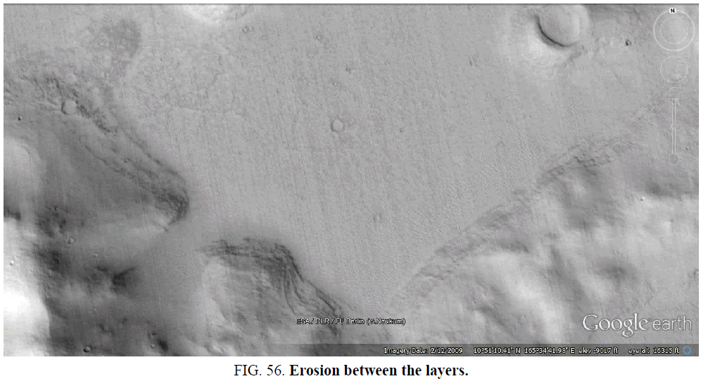
Multiple layers are visible in the central wall but not on the right wall in Figure. 56. Erosion seems to be happening between the layers in the middle, perhaps soil is spilling out.
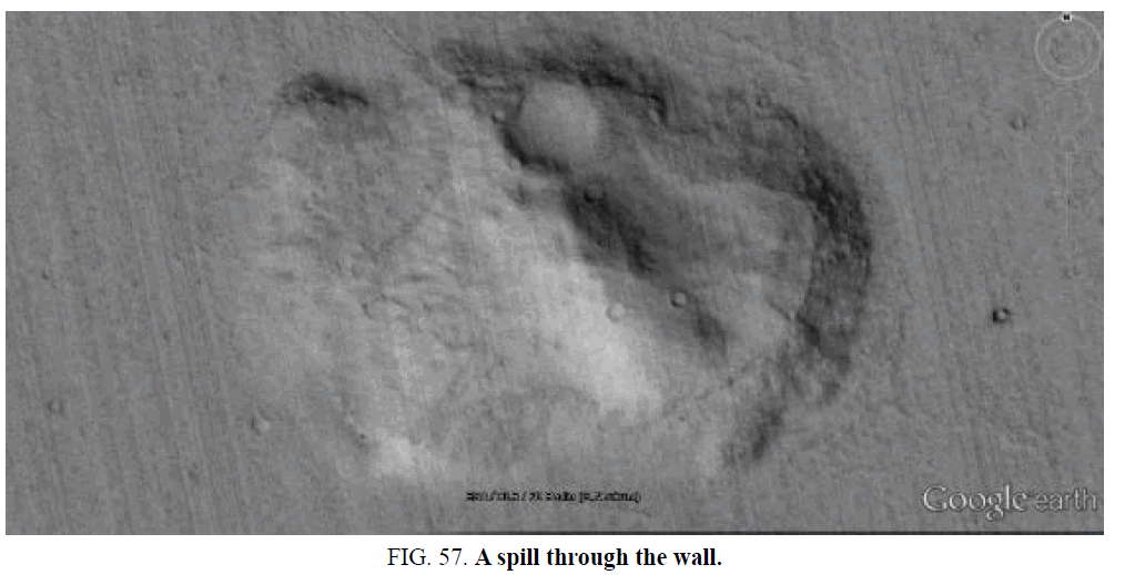
The wall seems to have broken around the upper side on the left of the crater in Figure. 57, soil spilling out. The middle right of the island is nearly flat and surrounded by this wall.
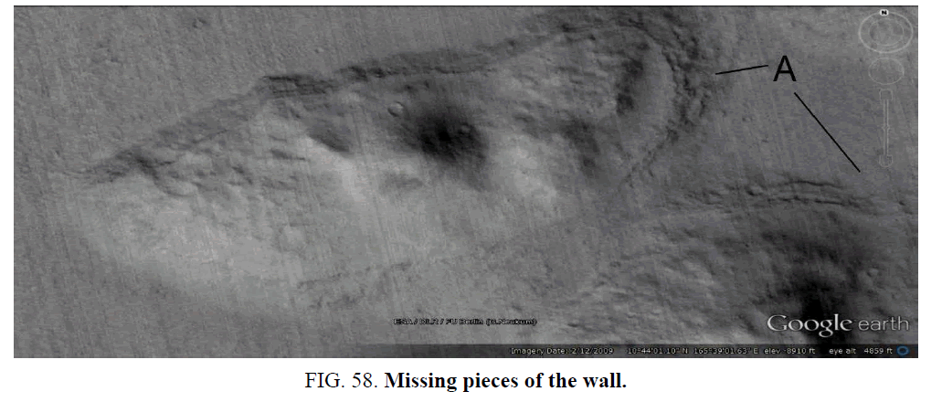
A highly preserved wall in Figure. 58 on the upper side and more degraded on the bottom. Some pieces of the wall are missing at A.
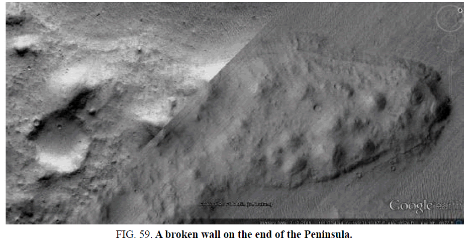
Another peninsula in Figure. 59 with flattened soil between the hills making a level surface. On its end the layers are breaking up and one piece is missing.
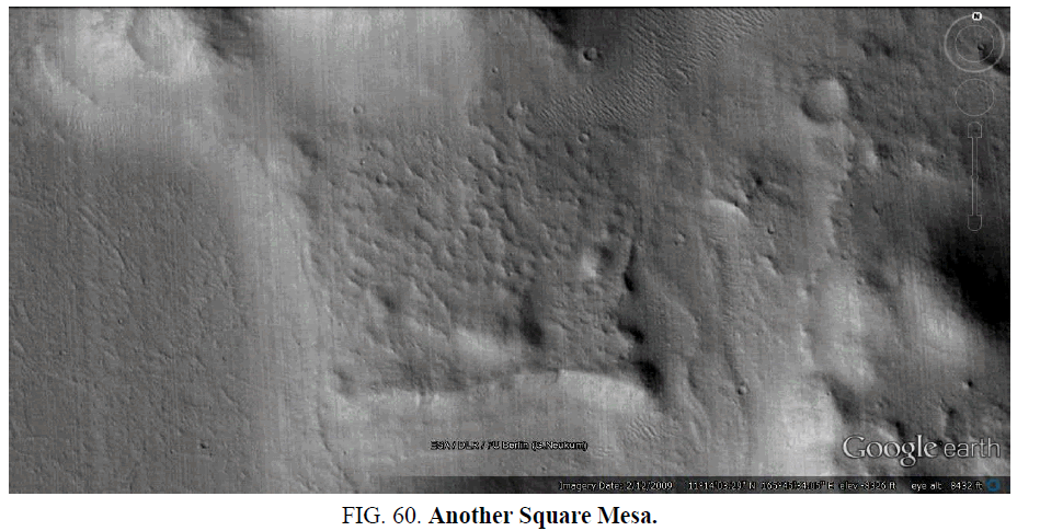
A squarish shape like the Square Mesa in Figure. 60. It is approximately straight on its upper and lower sides.
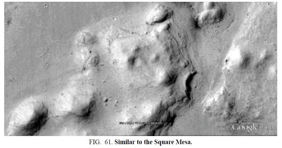
Another squarish shaped mesa in Figure. 61. The walls have similar layers on the right to the main Square Mesa. The layers are more eroded on the right.
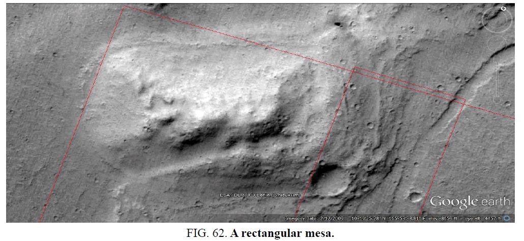
A rectangular mesa more like the Cydonia face in shape in Figure. 62. The red lines indicate it was reimaged by HiRise.
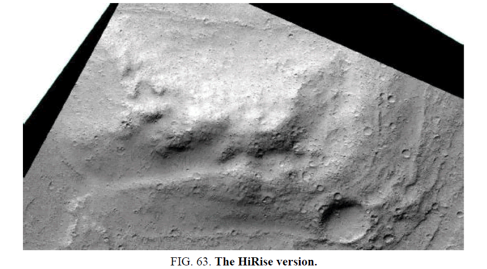
Here is the HiRise image of it in Figure. 63. The layers are visible like in the main Square Mesa.
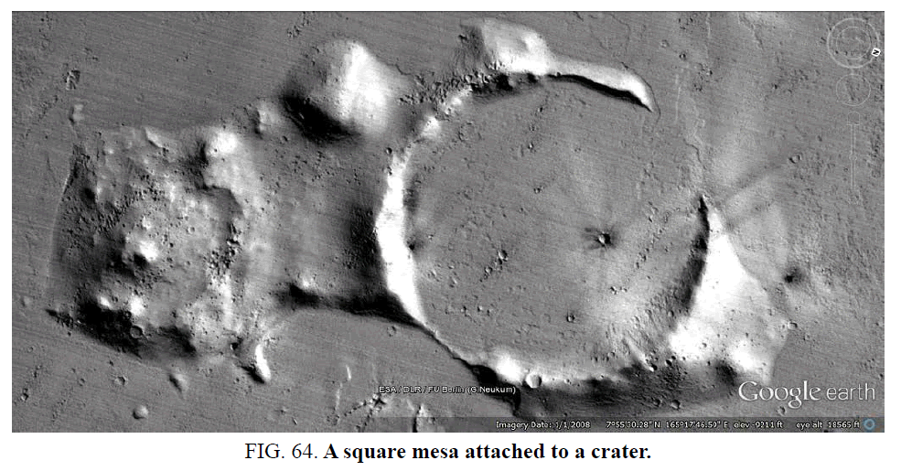
A squarish mesa on the left attached to a crater in Figure. 64. There is again an impression of an angled wall holding in sandy soil.
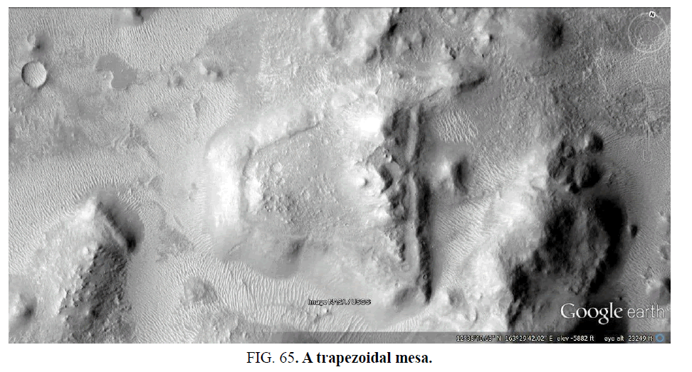
A more trapezoidal mesa with the same walls and flat soil around the mounds in Figure. 65.
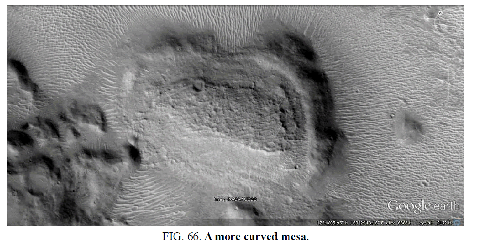
Another similar shape in Figure. 66, the walls seem to be holding in a lot of soil around the central rock to give a flatter surface. The walls appear to be much thicker and stronger on the right.
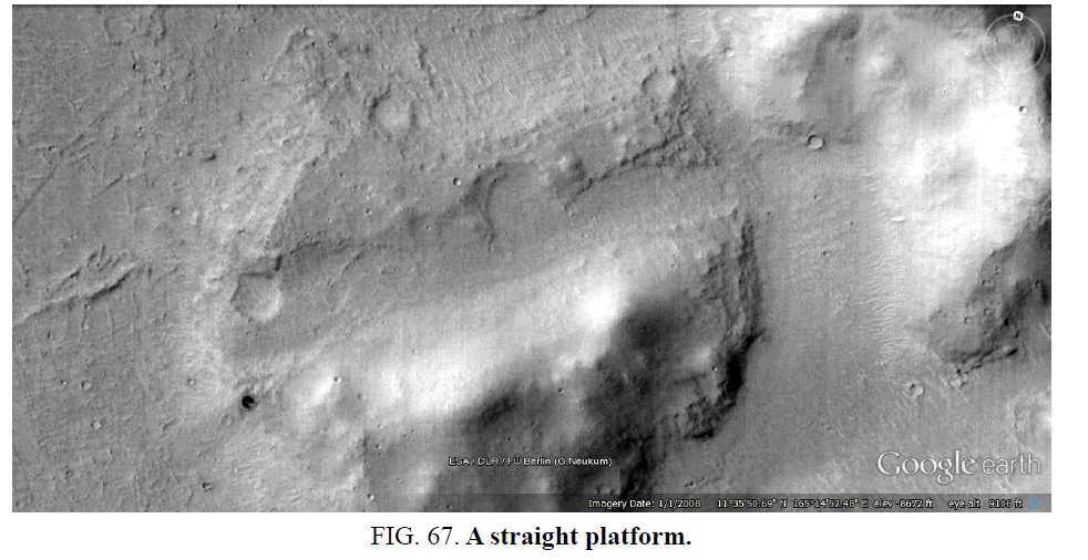
This has a straight gap through the rock in Figure. 67. This may have been used as a platform above the water.
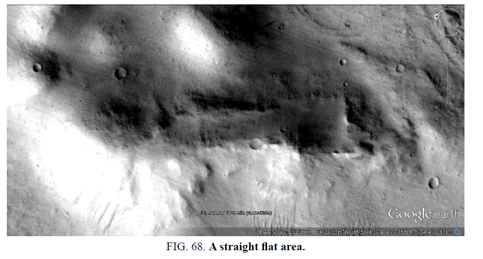
Another straight gap in Figure. 68. This may also have been a platform.
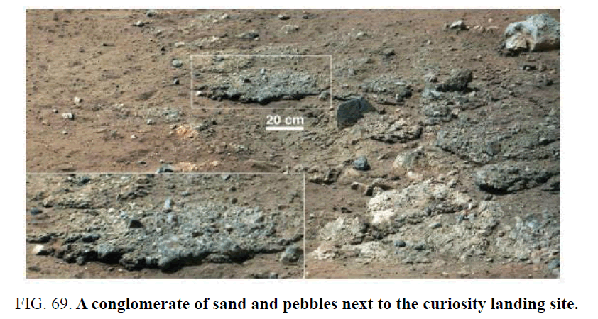
Nelson [14] discusses how finding water on Mars has raised hopes for finding past or even present life on Mars. Over 60 Martian meteorites have been found on Earth indicating an early wet Martian environment. Carr [15] suggests there could have been two oceans, a higher latitude one dating to 3.8 Ga and a more recent lower one associated with Elysium and its outflow channels. Either of these could have been associated with the Argyre impact hypothesis. The OMEGA/Mars Express mission found evidence to support these two periods of paleoseas, one had phyllosilicates formed by interacting with water and the second formed sulfates in an acidic environment. The Mars Odyssey used a neutron spectrometer that found the top meter of Martian soil contained the equivalent of 14 cm of water, including the polar ice this could have created a global average of 500 meters of ocean across the planet. This assumes that the water was there and has been lost, however the Argyre impact hypothesis can account for the flooding evidence using much less water. More recent estimates that may also have applied to this impact would cover Mars to a depth of 35 meters. This would be compatible with the Square Mesa and related formations in a shallow paleosea, it would also connect with the evidence of Kossacki et al. [5] concerning the depth of this paleosea (Figure. 69).
NASA announced in January 2014 that the Curiosity and Opportunity rovers were also searching for signs of ancient Mars life, Gale Crater is on the edge of Elysium near the Square Mesa formations and also close to the King’s Valley, it has the still functioning Curiosity Rover. Meridiani Planum had the Opportunity Rover and is where the Meridiani Face is located. These ancient water environments may have led to the early emergence of life. The Mars Exploration Program Analysis Group noted “Conclusive proof that liquid water existed for long periods on the ancient Martian surface. This strongly supports the idea of life developing on Mars around the time of the Argyre impact, the main issue is whether this life could have evolved sentience if these paleoseas and a warmer climate lasted for long enough. They also suggested “If life evolved there, conceivably it may still survive”.
Horneck [16] also discusses the amount of water on Mars, a range of 3.6 m to 133 m is indicated from the composition of the atmosphere with the D/H ratio, according to de Bergh [17]. Horneck also points out that life already existed on Earth 3.8 Ga ago at the same time, the Argyre impact could then have created a habitable environment that was fed by panspermia as Earth meteors transferred its life to Mars. Meteors falling into a paleosea would have their life inside them more likely to survive. The Martian atmosphere has a low shielding of 5 g/cm2 to 16 g/cm2, the lack of a magnetic field means a substantial portion of the cosmic radiation reaches the Martian surface. However, the Martian magnetic field should have still been operating at the time this paleosea existed, it has been suggested the Hellas impact caused it to slowly decrease over time. Also, any evolving life could have avoided radiation by either living in the paleosea or only coming out at night. Many Earth creatures are also nocturnal and would not present problems for life to evolve.
De Vera [18] discusses how many lichens can live and photosynthesize under current Martian conditions, with low temperatures, aridity, and high UV radiation. The warm and wet Mars after the Argyre impact would have been much more hospitable, also the UV radiation would have been reduced by clouds and the thicker atmosphere from volcanic outgassing. Using simulated Martian atmospheres, temperatures, humidity profiles and UV radiation spectra have shown photosynthetic activity of Xanthoria elegans. Lithopanspermia is the viable transport of microorganisms via meteorites, experiments have been performed to test the three steps of the lithopanspermia process. Viable transfer from Earth to Mars requires that microorganisms survive the ejection into space by the impact of an asteroid or comet on Earth. Secondly, they must survive the journey through space, with timescales ranging between 1 and 20 million years. The third step is the entry into the Martian atmosphere. The second step has been tested by space experiments, the first step by meteorite impact simulation tests using explosive devices. The ejection of the organic material is assessed to be exposed to 5 GPa to 50 GPa, lichen has been shown to survive in this range. While there has been less success with re-entry the falling of meteors into a paleosea might have allowed the lichen to survive, more testing is needed.
Schuerger [19] tested the biotoxicity of Martian soil, six Martian soil mixtures were created to simulate a range of potentially biotoxic geochemistry. They included basalt-only (non-toxic control), salt, acidic, alkaline, Aeolian, and perchlorate rich geochemistry. Six eubacteria were tested for tolerance to desiccation, the Bacillus subtilis HA101 and Enterococcus faecalis ATCC 29212 were found to be resistant. Tests with B. subtilis and E. faecalis showed that 1 mm of Mars analog soil fully attenuated the biocidal effects of a simulated Mars-normal equatorial UV flux. In the Argyre impact hypothesis the condition for life should have been much more hospitable, there would have been abundant water from the melting poles. Also, the radiation would have been lower with the functioning magnetic field and cloud cover from weather patterns. If this life was evolving in the ocean, then the conditions may have been as hospitable as on Earth. They conclude that Mars soils are not overtly biotoxic and suggest that the soil geochemistry on Mars will not preclude the habitability of the Martian surface even in the current environment.
Kuhn [20] discusses the Mars Science Lab Curiosity landing at Gale crater on August 6, 2012.
This area, near the King’s Valley and the Square Mesa formations was chosen because it offered a wide range of past aqueous and thus, potentially habitable environments. It had outflow channels, an alluvial fan, as well as finely bedded deposits containing strata with phyllosilicates and sulfates. The landing site had many features associated with deposition by water, the life-bearing potential of the analyzed sites was indicated by layers of sedimentary rocks and a gravel conglomerate. It’s likely then these same features would be found around and perhaps in the King’s Valley, a fluvial valley close to Gale Crater and containing possible artefacts.
The type of deposition according to Kuhn [20] is indicative of sediment deposition from a flowing stream of water slowing down rapidly, such as when leaving the confines of a channel. The rover had apparently landed on an alluvial fan, the flow velocity and depth of runoff from the crater wall was estimated at 3 cm to 90 cm deep and flowing at a velocity of 2 cm/s to 75 cm/s. The Sheep bed sediments showed strong evidence that they formed in a lacustrine, i.e. shoreline-type of environment that would offer habitability for microorganisms [21]. Some features point toward a wet deposition of Sheep bed, the chemically uniform layer of mudstone is approximately 2 m thick. Accumulation of a fine lake sediment layer of similar thickness requires between 100s and 1000s of years. The Sheep bed sediments revealed that the area would have been habitable for chemolithotrophic microorganisms [22]. The presence of hydrogen sulfides as an energy source and a pH in a near-neutral range, also essential elements for life such as carbon, nitrogen, and phosphorus were detected that would enable their use by microorganisms. The lake in which the Sheep bed sediments formed would have been habitable for the type of microorganisms expected to have evolved on Mars.
Conclusions
The Square Mesa and related formations are hypothesized to have been islands in a paleosea that lasted over 1 Ga, the water would also have been heated by the rise of and long lived heat from Elysium Mons, Hecate Tholus, and Alba Tholus. Similar life compatible geology may exist on these formations to that found by the Curiosity Rover in nearby Gale Crater. The biotoxicity of Martian soil should have allowed for life to evolve in this area, lithopanspermia may have allowed for microorganisms such as lichen to be transported from Earth to Mars into this paleosea [23-26]. Platy deposits indicate pack ice on this paleosea with fewer signs of ice nearer Elysium Mons and the Square Mesa formations. It is likely to have been more hospitable for life there. The depth of this paleosea would have been consistent with the height of these islands. The wall like shapes on these formations occur only on some islands but not on others close by in the same geological conditions and processes involved in their creation. Often these walls are on one side only of these islands though the same geological process would be expected to go all around them. The Square Mesa shows signs of bricks of the same size repeating, also layers of constant thickness. The theme of a sandy interior shored up by these walls is a proposed hypothesis for their creation [27-29]. This area would have been initially one of the first to have a paleosea under the Argyre impact hypothesis, then with polar wander it would have remained on the equator heated by Elysium Mons. It appears then to be a prime location for artefacts to be found from a hypothetical evolved sentient species. Because these formations are so different from natural formations in the area it is proposed the null hypothesis is falsified and that some of these are artificial.
References
- Viking 1 & 2. NASA Mars Exploration. Program & Missions. 1975.
- DiPietro V, Molenaar G. Unusual Martian Surface Features. Mars Research. 1982.
- Carlotto M. The Cydonia Controversy. Lulu.com; 2008. 47p.
- Boeche R. Journal of the Fortean Research Center Paperbound. Lulu.com; 2012. 10p.
- Carlotto M. The Cydonia Controversy. Lulu.com; 2008. 47p.
- Mark JC. Analysis of Mars Odyssey THEMIS Imagery of the "D&M Pyramid. New Frontiers in Science. 2002;1(3).
- Mars Reconnaissance Orbiter HiRISE, [Internet]. Exclamation Mark on Mars, ESP_020794_1860, dated January 2, 2011. http://www.uahirise.org/ESP_020794_1860.
- George Haas. Personal e-mail communication from Greg Orme, July 17, 2013.
- Mars Odyssey THEMIS. About Mars Odyssey &themis [internet]. Mars Space Flight Facility, Arizona State University [cited on 2016 November 16]. Available from: http://themis.asu.edu/about
- James Miller. Personal e-mail communication with the Principal Investigator for the 2001 Mars Odyssey Thermal Emission Imaging System (THEMIS) instrument, Philip Christensen, July 18, 2002.
- Mars Odyssey (2007) THEMIS image V26406033, dated November 27
- Mars Reconnaissance Orbiter HiRISE, Libya Montes, CTX P14_006672_1836_XN_03N267W, December 29, 2007. http://hirisepds.lpl.arizona.edu/PDS/EXTRAS/RDR/ESP/ORB_020700_020799/ESP_020794_1860/ESP_020794_1860_RED.browse.jpg
- Mars Reconnaissance Orbiter HiRISE, Exclamation Mark on Mars, ESP_020794_1860, January 2, 2011. http://www.uahirise.org/ESP_020794_1860.
- Dr. Alfred S. McEwen, The Department of Planetary Sciences/Lunar and Planetary Laboratory. http://www.lpl.arizona.edu/people/faculty/mcewen.html
- Dr. Alfred S. McEwen, Exclamation Mark on Mars, NASA/JPL/University of Arizona, January, 12, 2011.
- Nichido Contemporary Art, Viki Muniz, Pictures of Earthwork, (Chuo-ku, Tokyo, Japan), 2009.
- Stephen D. Peet, State Historical Society of Wisconsin, Collections-State Historical Society of Wisconsin, (The University of California, General Books LLC, 1882), 49.
- David L. Kennedy, Desktop Archeology, Aramco World, July/August, Volume 60, Number 4, 2009.
- Kessler R. Thousands of Tombs in Saudi Desert Spotted from Space. Live Science. February 15, 2011.
- Carolina Sparavigna A. A Prehistoric Solar Observatory in the Middle of Sahara Desert. 2014:428.
- Heritage of Japan. Discovering the Historical Context and Culture of the People of Japan. Towering tumuli of the Kofun era. 2013, 4p.
- Schoch R. Secrets of the Tombs. Ancient Aliens. Season 5 Episode aired January 25, 2013.


