Original Article
, Volume: 5( 2)Image Analysis of Unusual Structures on the Far Side of the Moon in the Crater Paracelsus C
- *Correspondence:
- Carlotto MJ , The Lunascan Project, Society for Planetary SETI Research, Tennessee, USA, Tel: 978-807-7758; E-mail: mark@carlotto.us
Received: July 26, 2016; Accepted: September 20, 2016; Published: September 30, 2016
Citation: Carlotto MJ, Ridge FL, Sirisena AL. Image Analysis of Unusual Structures on the Far Side of the Moon in the Crater Paracelsus C. J Space Explor. 2016;5(2):102.
Abstract
The authors present an analysis of Apollo 15 and Lunar Reconnaissance Orbiter images of two unusual features in the crater Paracelsus C on the far side of the moon. At first glance these structures appear to be walls or towers on the lunar surface. By combining multiple images, we show the larger feature, oriented in a northeast/southwest direction, is not simply a wall but two walls on either side of a narrow valley or â€ÂÂÂÂœpassagewayâ€ÂÂÂÂÂÂ. Using single image shape from shading and 3D terrain visualization we show in a computer-generated perspective view looking northeast that the southwest end appears to be the entrance to the passageway. A reverse angle view looking southwest shows the passageway ending at a rise of terrain at the other end, possibly leading underground. The terrain surrounding the two structures is not flat but appears â€ÂÂÂÂœexcavated†by some unknown mechanism, natural or artificial. It is shown that these objects are visually different from the lunar background because their underlying structure is different.
Keywords
Paracelsus C; Moon; Lunar
Introduction
The search for extra-terrestrial intelligence (SETI) began in the 1960s with radio-telescopes and has, to date, produced no positive evidence of its existence. During these early years of SETI, Sagan [1] spoke about the possibility of extraterrestrial visitation, “It is not out of the question that artifacts of these visits still exist, or even that some kind of base is maintained (possibly automatically) within the solar system to provide continuity for successive expeditions. Because of weathering and the possibility of detection and interference by the inhabitants of the Earth, it would be preferable not to erect such a base on the Earth’s surface. The Moon seems one reasonable alternative. Forthcoming high resolution photographic reconnaissance of the Moon from space vehicles – particularly of the back side – might bear these possibilities in mind”.
Foster [2] estimated frequencies of visitations by extraterrestrials or their messenger probes and suggested the possibility that past encounters may have left behind artifacts or indirect evidence (e.g., deranged planetary terrain). Seeking a broader alternative to radio SETI, a search for extraterrestrial artifacts (SETA) was proposed in the 1980s [3]. The search for alien artifacts on the moon [4,5] is an outgrowth of this more inclusive search strategy.
Davies [6] called for a citizen science approach to SETI stating “rather than leaving SETI to a small and heroic band of radio astronomers, we should mobilize the entire scientific community to ‘keep their eyes open’ for telltale signs of alien technological activity.” One suggestion is to look for evidence of mining or quarrying activities. Where on the Earth the evidence may be buried beneath overlaying strata, Davies [6] believes “Quarrying or construction on the moon or asteroids would persist conspicuously for much longer, and scrutiny of the Lunar Reconnaissance Orbiter data would be a useful exercise”.
This paper provides evidence supporting the hypothesis that certain features in the crater Paracelsus C on the far side of the moon may be artificial in origin. “Background” summarizes the discovery of these features – a case study in citizen science. Many times, objects that appear unusual in older lower resolution photographs turn out to be unremarkable in higher resolution digital images. Analysis of LRO images in “Preliminary Image Analysis” including coregistered and ‘fused’ images at different sun angles reveals this is not the case. The question of artificiality in the context of the surrounding terrain is considered in “Lunar Context” section. “Three-Dimensional Analysis” section presents 3-D visualizations of the features and the surrounding area to assist in their interpretation. Areas for future work are discussed in “Discussion” section.
Background
Reports of artificial structures on the moon in Apollo and Lunar Orbiter photographs are not uncommon in the popular press and the Internet. Among the first were Leonard’s [7] “Somebody Else is On the Moon” and Steckling’s [8] “We Discovered Alien Bases on the Moon” which identified a large number of unusual features in Lunar Orbiter and Apollo photographs. Literally hundreds of reports can be found online today, many of which can be traced back to these books.
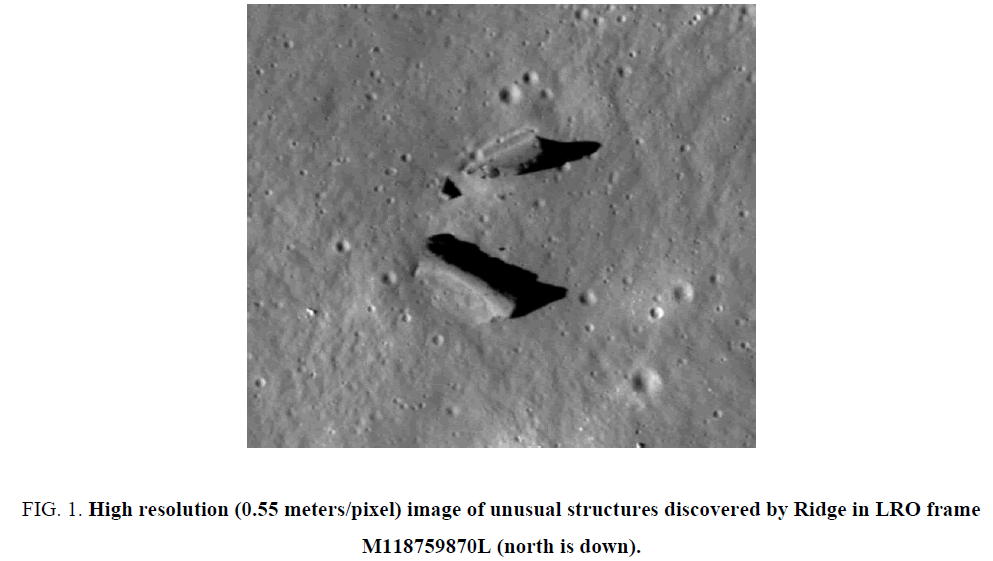
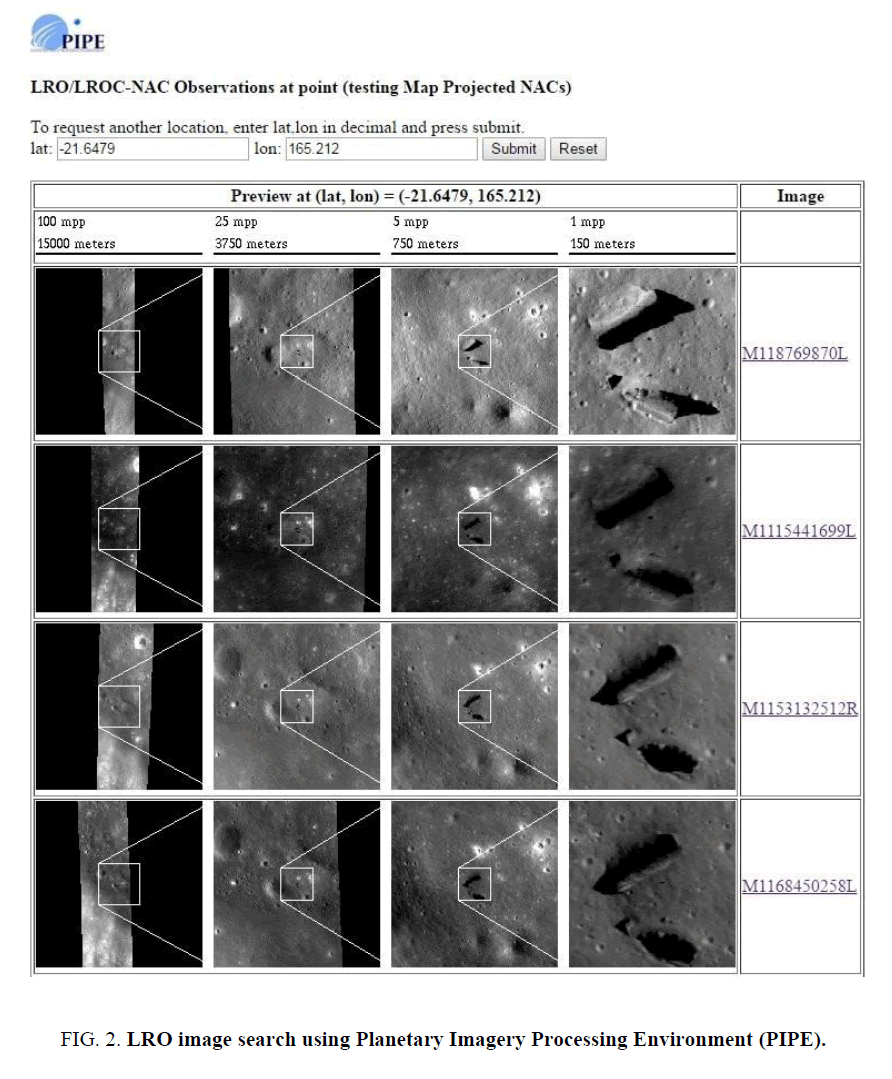
Independent scientific groups such as The Lunascan Project [9] and Society of Planetary SETI Research [10] investigate reported anomalies on the moon, Mars, and elsewhere. In May 2016, SPSR member Ananda Sirisena notified Lunascan project coordinator Francis Ridge that he had found an article posted on the Internet in 2014 [11] reporting the discovery of unusual features on the surface of the moon in the crater Paracelsus resembling dark "walls" or "towers" photographed by the Apollo 15 astronauts. Ridge determined the coordinates of the features and located a high resolution Lunar Reconnaissance Orbiter (LRO) image M118769870L that contained two unusual structures (Figure. 1). After finding the Apollo 15 panoramic camera image A15-P-8868 referenced in the article, Ridge realized the structures in the LRO image were the same features mentioned in the article. Sirisena then identified another Apollo 15 image (AS15-P-8873) over the same area taken at a different viewing angle. Three images acquired by two satellites from different viewing angles proved the features were not an optical illusion. Many times objects that appear unusual in older lower resolution photographs turn out to be unremarkable in higher resolution digital images. This was clearly not the case in the high resolution LRO image Ridge has found. The features appeared even more unusual up close. Three additional LRO M-frames were found using the Planetary Imagery Processing Environment (Figure. 2). In total, four LRO M-frames, two Apollo 15 P-frames, and five Apollo metric camera M-frames were located over the area (Table 1).
Figure 1: High resolution (0.55 meters/pixel) image of unusual structures discovered by Ridge in LRO frame M118759870L (north is down).
| Frame | Resolution (meters) | Solar Elevation | Emission Angle | Incidence Angle | Phase Angle |
|---|---|---|---|---|---|
| AS15-P-8868 | 14 | (forward) | |||
| AS15-P-8873 | 14 | (aft) | |||
| AS15-M-0081 | 6.4 | 14 | |||
| AS15-M-0082 | 6.3 | 14 | |||
| AS15-M-0083 | 6.3 | 15 | |||
| AS15-M-0084 | 6.5 | 16 | |||
| AS15-M-0085 | 6.5 | 16 | |||
| M118769870L | 0.55 | 1.7 | 68.9 | 70.5 | |
| M1115441699L | 0.8 | 1.7 | 34.4 | 35.8 | |
| M1153132512R | 0.94 | 1.2 | 58.7 | 57.6 | |
| M1168450258L | 0.90 | 1.7 | 54.6 | 56.3 |
Table 1: Apollo and LRO images over the area of interest.
Preliminary Image Analysis
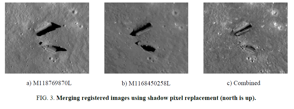
Figure. 3a and Figure. 3b are map-projected images of the features of interest in M118769870L and M1168450258L, respectively. North is up. The larger feature (A) is oriented in a northeast/southwest direction. The smaller features (B) to the south is oriented in a northwest/southeast direction. In Table 1, the sun is to the west-northwest, illuminating the northwest side of feature A in frames M118769870L and M1115441699L. In M1153132512R and M1168450258L the sun is east-northeast, illuminating the southeast side of A. At this sun angle the terrain to the north casts a shadow along the northwest side.
Using LRO image M118769870L and associated metadata [12], the length of A is:
L=M × R=235 pixels × 0.55 meters/pixel=129 meters (1)
where M is its measured length in pixels and R is the pixel resolution. The length of B is 77 meters.
The height of A can be calculated from the measured length of its shadow, N. Assuming for the moment the shadow is cast on flat terrain, the height at the northeast end is
 (3)
(3)
where φi is the solar incidence angle. The height at the southwest end is about 19 meters. The height of the northeast end of A estimated from M1168450258L [13] is 31.1 meters, which within 10% of the first estimate (Eq. 2). Interestingly the height of B is slightly higher, about 29.5 meters as estimated from M118769870L.
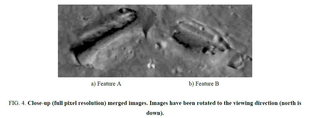
Combining multiple images reveal new information about these structures that is not evident in the original data. In Figure. 3c the two images have been merged by replacing shadowed pixels in one image with non-shadowed pixels in the other image, and vice versa. In Figure. 3a the sun is to the left, in Figure. 3b the sun is to the right. The resultant merged image reveals A is not simply a “wall” but appears to be two “walls” on either side of a narrow valley or “passageway” (Figure. 4a). B appears to have a ridge-like depression in the middle similar to A as shown in Figure. 4b). These details are discussed further in “Three-Dimensional Analysis” section.
Figure 4: Close-up (full pixel resolution) merged images. Images have been rotated to the viewing direction (north is down).
Lunar Context
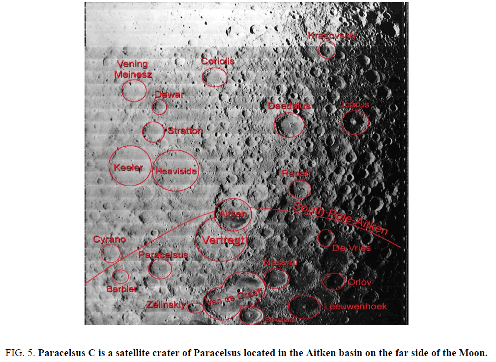
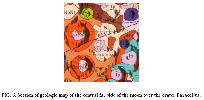
These features are in the southwest corner of a 24 km crater named Paracelsus C. Paracelsus C is one of number of “satellite” craters of Paracelsus, an impact crater on the far side of the moon (Figure 5). It is located in the Aitken basin – one of the largest, oldest and deepest basin on the Moon [14]. With reference to Figure. 6 the area is geologically diverse, containing rolling terrain with a moderately high density of craters less than 20 km in diameter (Nt), smooth light plains (Ip), and uplifted and complex faulted pre-basin bedrock covered by basin ejecta (NpNbr). Given the complexity of the terrain, is it possible that these features are simply uplifted bedrock surrounded by smooth plains? Although it is not possible to definitively determine the origin of these features from the imagery it can be shown that they are quantitatively different from the surrounding terrain. Sagan [15] argued that deviations from thermodynamic equilibrium are a necessary (but not sufficient) condition of intelligent activity. He cited significant deviations from the blackbody radiation curve of Earth in the radio frequency portion of the electromagnetic spectrum as evidence of terrestrial intelligence, and went on to show that passive (electro-optical) imaging of Earth at resolutions (spatial scales) smaller than about 1 km reveals evidence of mechanical disequilibrium (e.g., rectilinear patterns of agriculture, road networks, etc.).
Figure 5: Paracelsus C is a satellite crater of Paracelsus located in the Aitken basin on the far side of the Moon.
Stein [16] developed an algorithm that models images as fractals. Images of natural backgrounds, like the backgrounds themselves, exhibit a property known as self-similarity that have a distinctive power spectral density
 (3)
(3)
where 2<D<3. Deviations from this curve, like that from blackbody radiation indicate possible non-natural, i.e., artificial phenomena. Stein’s algorithm has been used in several SETA investigations already [4,17].
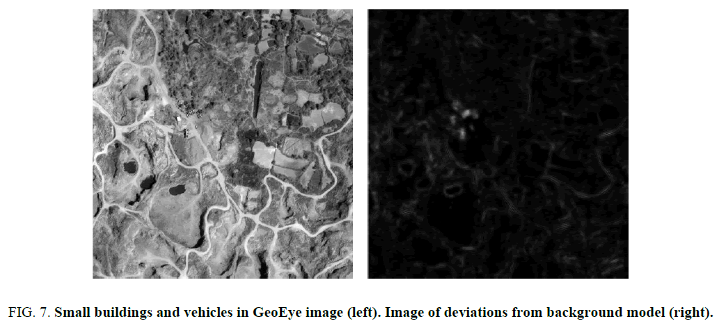
Analysis of the statistics of natural terrestrial backgrounds (forested areas, drainage patterns, tectonic features, etc.) and artificial features (e.g., roads, cities, vehicles, archaeological ruins) reveal artificial structures produce anisotropies in the 2D power spectrum at particular scales or resolutions [18]. A biologically-inspired target screener [19] models the background using a bank of 64 Gabor filters, which measure the local power spectral density (4 scales × 16 directions). The detection statistic
d=(x−m)T C−1(x−m) (4)
measures the deviation from the background, which is modeled as a Gaussian random variable with mean m and covariance C. The algorithm detects areas in the image containing objects with non-isotropic power spectra like buildings and vehicles (Figure. 7) Figure. 8 is the result of applying the same algorithm to a portion of LRO frame M118769870L. The area is 4096 × 4096 pixels at 0.55 meters/pixel or about 507 sq. km. The local power spectra of the features under study as well as several nearby craters appear to deviate significantly from that of the lunar background. These objects are visually different from the background because their structure is different.
Figure 7: Small buildings and vehicles in GeoEye image (left). Image of deviations from background model (right).
Figure 8: Portion of vertically-flipped LRO image M118769870L centered over structures (left). North is up. Image of deviations from background model (right).
Three-Dimensional Analysis
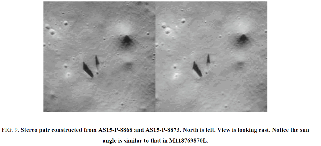
Viewing the data in 3D further aids in our ability to understand the shape of these structures and their relation to the background. Two images at different angles and similar sun angles can be viewed side by side in stereo. The Apollo 15 images AS15-P-8868 and AS15-P-8873 are good candidates for stereo work as they were acquired from opposite but unknown viewing angles (noted only as “fore” and “aft” in the metadata) at the same sun angle. Although feature A is only about 10 pixels in size in the P frames and even smaller in the lower resolution M frames it is apparent that the features are slightly lower in elevation than the terrain to the west (Figure. 9).
Figure 9: Stereo pair constructed from AS15-P-8868 and AS15-P-8873. North is left. View is looking east. Notice the sun angle is similar to that in M118769870L.
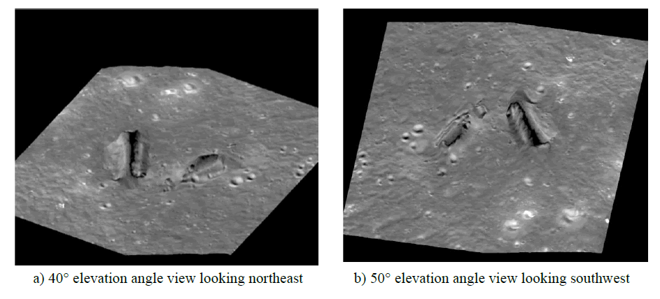
Available elevation maps of the moon do not have sufficient resolution to resolve the features under study. Shape from shading (SFS), also called photoclinometry, is another method of extracting height information from images [20]. SFS is useful in situations where the reflectance characteristics and albedo are uniform across the scene and the image is acquired at or near nadir. SFS methods assume an underlying scene reflectance function relating surface gradients to image brightness. Pentland [21] derives a linear approximation for the Lambertian reflectance function, which is a good model for matte surfaces. A similar linear approximation can be derived for the lunar surface. Embedding this within a strip integration algorithm described by Horn [20] we computed height maps from the two merged LRO images, M118769870L and M1168450258L and averaged them together to create a relative height surface. At this point, synthetic views can be generated in any viewing direction by an oblique parallel projection of the merged image mapped onto the height surface [22]. Figure. 10a is a view at a 40° elevation angle looking northeast. From this viewing angle the southwest end of feature A appears to be the “entrance” into the passageway. Figure. 10b is a reverse angle view looking southwest that seems to show the passageway ending at the rise of terrain at the other end.
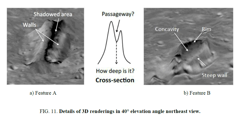
Full pixel resolution northeast views of the two structures are shown in Figure. 11. There is insufficient information in the imagery to determine the depth of the valley in between the two walls. It is also not possible to determine if the valley ends or leads underground. The 3D view of feature B reveals a radically different shape from that of A. What appears to be a long thin depression is in fact a steep cliff. The top of B is concave with a rim along the opposite side. The terrain surrounding the two structures is not flat but appears “excavated” by some unknown mechanism.
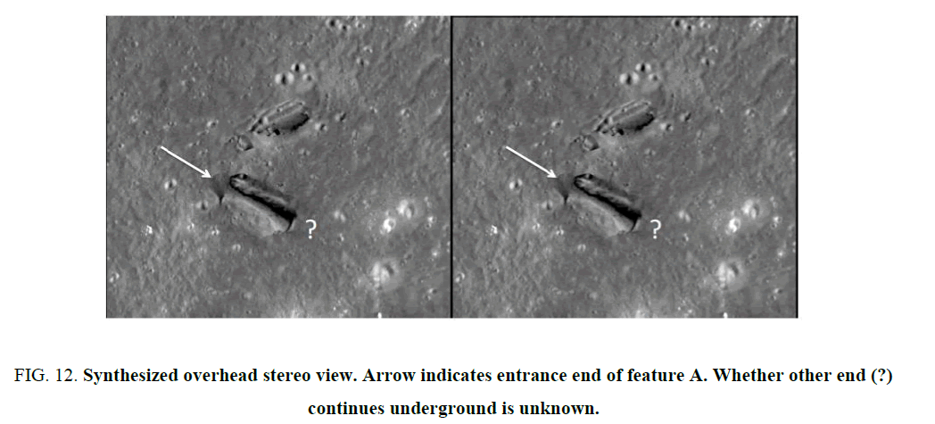
Figure. 12 is a side by side overhead stereo view synthesized from the merged image and height map demonstrating the relation of feature A with the background topography. It is evident that the entrance end (indicated by the arrow) is lower in height than the other end (?), which may or may not continue underground. Notice the depressed terrain immediately above and below the feature. Could this area have been “excavated” by some mechanism, natural or artificial.
Figure 12: Synthesized overhead stereo view. Arrow indicates entrance end of feature A. Whether other end (?) continues underground is unknown.
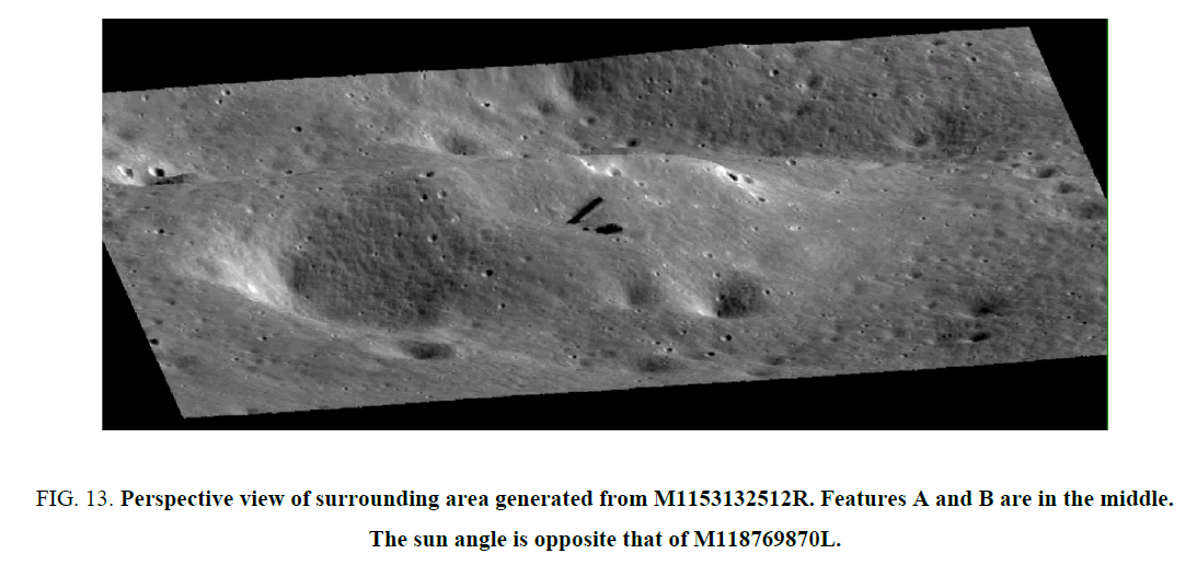
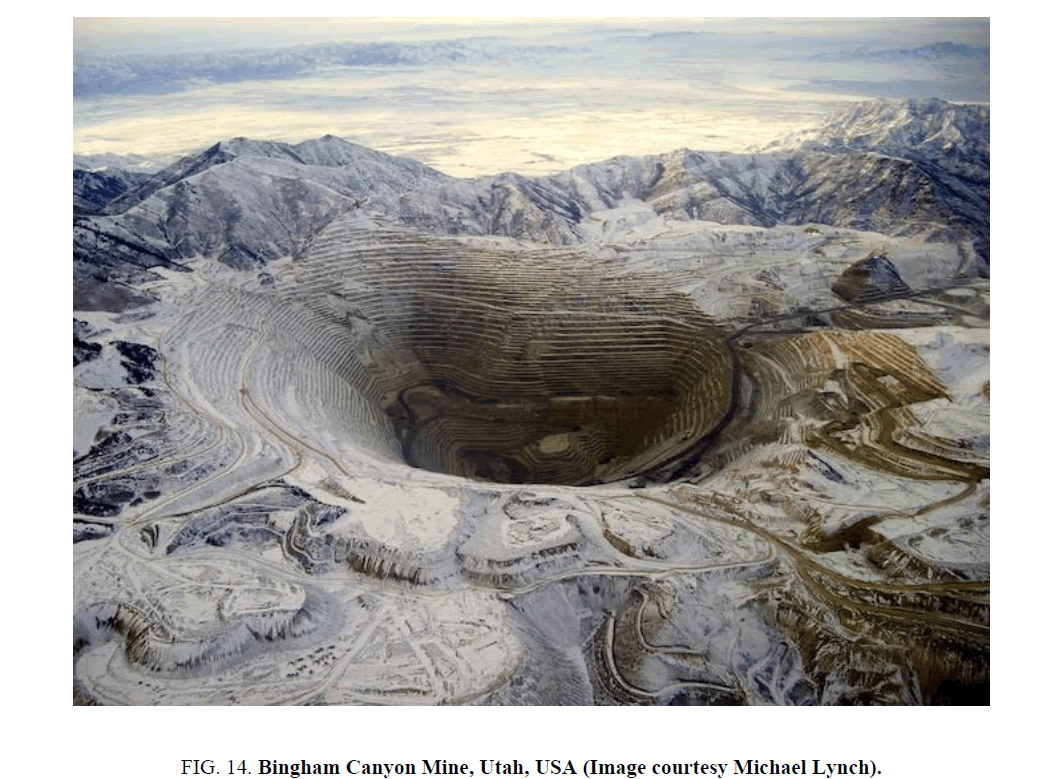
Figure. 13 is a perspective view of a wider area containing the features of interest generated from M1153132512R [23]. Davies [6] suggested the possibility of detecting abandoned alien mining or construction operations on the moon. As a point of comparison, the terrain surrounding the features under investigation is not unlike that of the Bingham Canyon copper mine southwest of Salt Lake City, Utah Figure. 14. However, the area immediately surrounding the features lacks the terraced sides one would find in a terrestrial mine.
Figure 13: Perspective view of surrounding area generated from M1153132512R. Features A and B are in the middle. The sun angle is opposite that of M118769870L.
Discussion
Enormous quantities of lunar and planetary imagery are available to the public by way of the Internet. While enabling a “citizen science” approach to SETI, the availability of so much data also tends to generate new “discoveries” on a regular basis by those who want to discover something such as alien bases, towers, construction and other activities on the lunar surface. Although most of these findings turn out to be camera aberrations, image compression/transmission errors, image enhancement artifacts, or simply misinterpretations of unfamiliar surface features imaged in unfamiliar ways, some remain unexplained.
A decidedly conservative mainstream scientific establishment often rejects anomalies based on subject matter alone, i.e., there cannot be alien artifacts on the moon because there are no alien artifacts on the moon (or other planets). Such a view is an example of circular reasoning, based on the belief that extraterrestrials do not exist, or if they do exist that they could not have traveled to our solar system.
SETI has been criticized on epistemological grounds, i.e., we are looking for what we think is out there [24]. In order to carry out an objective search for artificial features on the moon and planetary surfaces, objective detection criteria must be established. Since we do not really know what we are looking for, it is not possible to define in a direct way what is artificial. An indirect approach is to develop a model of what is natural and detect deviations from the model using anomaly detection. Several anomaly detection techniques that have been used in this way include fractal models [16], those discussed by Arkhipov [4], comparative statistics [18], and the biologically-inspired method [19] applied in “Lunar Context” section.
These or other methods deployed in a cloud based or similar computing environment (e.g., seti@home11) could be used by a global citizen science community to develop a list of candidate sites for more in-depth investigation.
Based on the evidence presented in this paper we believe this area in Paracelsus C is one such candidate that is worthy of future study by orbital missions and surface rovers. Both of the features analyzed in this area are statistically different from the surrounding terrain. Feature A has a structure unlike any feature seen on the moon to date. Its relation with the surrounding terrain suggests an entrance and passageway that may lead underground based on 3D evidence, with signs of excavation on both sides of the feature. Feature B also appears unusual but was analyzed to a lesser extent.
Beyond the initial results presented here areas for additional work include collecting additional imagery over the area at other solar/viewing angles in order to assess the interior structure of feature A, refining the 3D models of features A and B (“Three-Dimensional Analysis” section) using photometric stereo [25] or other methods, and extending the background modeling and analysis (“Lunar Context” section) to a much larger area on the moon.
References
- Sagan C. Direct contact among galactic civilizations by relativistic interstellar spaceflight. Planetary and Space Science. 1963;11:485-98.
- Foster GV. Non-human artifacts in the solar system. Spaceflight. 1972;14:447-53.
- Freitas RA. If they are here, where are they? Observational and search considerations. Icarus. 1983;55:337-43.
- Arkhipov V. Earth-moon system as a collector of alien artefacts. J Br Interplanet Soc. 1998;51:181-4.
- Davies PCW, Wagner RV. Searching for alien artifacts on the moon. Acta Astronautica. 2013;89:261-5.
- Davies PCW. Footprints of alien technology. Acta Astronautica. 2012;73;250-7.
- Leonard G. Somebody Else is On the Moon; 1976.
- Steckling F. We Discovered Alien Bases on the Moon; 1981.
- http://www.astrosurf.com/lunascan/
- http://spsr.utsi.edu
- http://www.ufosightingsdaily.com/2014/01/new-moon-discovery-of-two-tall.html
- http://wms.lroc.asu.edu/lroc/view_lroc/LRO-L-LROC-3-CDR-V1.0/M118769870LC
- http://wms.lroc.asu.edu/lroc/view_lroc/LRO-L-LROC-3-CDR-V1.0/M1168450258LC
- Petro NE, Pieters CM. Surviving the heavy bombardment: Ancient material at the surface of South Pole ? Aitken Basin. J Geophy Res. 2004;109.
- Sagan C. The recognition of extraterrestrial intelligence. Proc Royal Soc. 1975;189:143-53.
- Stein MC. Fractal image models and object detection. Soc Photo-opt Instru Eng. 1987;845:293-300.
- Carlotto MJ, Stein MC. A method for searching for artificial objects on planetary surfaces. J Br Interplanet Soc. 1990;43:209-16.
- Carlotto MJ. Detecting Patterns of a Technological Intelligence in Remotely-Sensed Imagery. J Br Interplanet Soc. 2007;60;28-39.
- Carlotto MJ. BiTS - A biologically-inspired target screener for detecting manmade objects in natural clutter backgrounds. SPIE Defense and Security, April 5-9, 2010, Orlando, Florida, USA; 2010.
- Horn BKP. Understanding image intensities. Artif Intell. 1977;8:201-31.
- Pentland A. The transform method for shape-from-shading. MIT Media Lab Vision Sciences Tech. Report. 1988;106.
- Foley JD, Van Dam A. Fundamentals of interactive computer graphics. Boston: Addison-Wesley Longman Publishing Co., Inc., MA, USA; 1983.
- http://wms.lroc.asu.edu/lroc/view_lroc/LRO-L-LROC-3-CDR-V1.0/M1153132512RC
- Denton T. Dancing in our lenses: Why there are not more technological civilizations. J Br Interplanet Soc. 1984;37:522-5.
- Horn BKP. Hill shading and the reflectance map. Image Understanding Workshop, Palo Alto, CA, USA; 1979.
